Grants:IEG/Wikimaps Warper 2.0
![]() This project is funded by an Individual Engagement Grant
This project is funded by an Individual Engagement Grant

Project idea
editWhat is the problem you're trying to solve?
editThe Wikimaps project wishes to make collecting and displaying historical geographic data fun and easy for everyone. Old maps, images, historical data and common visualization techniques together will allow historical phenomena to be illustrated in Wikipedias in many captivating ways.
What is your solution?
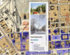
editWe have started to put the necessary pieces together to achieve this. Wikimaps Warper has been made available for maps in Wikimedia Commons in the Wikimaps project. It is a tool to rectify maps. That means that a scan of a historical map is stretched to match the present-day map. The resulting “corrected” maps can then be used as layers in applications and visualizations, overlaid with any other geographic data.
The vision goes further. Wikimaps has been working with OpenHistoricalMap, an OpenStreetMap project for history. The iD editor, which is used to copy features from scanned maps or aerial images into a map of the world through times, is available within the Wikimaps Warper. Our goal is to facilitate the upload of thousands of maps from the dusty map archives to Wikimedia Commons, mapping to OpenHistoricalMap, and connecting the historical geodata to Wikidata.
We have installed and modified Wikimaps Warper in Wikimedia Labs. We are looking for support to make it easily extendable and flexible to allow other developers to join. The goal is to decouple the front end from the back end, and different functionalities from each other. The resulting code will be made accessible through an API, which will allow anyone to build applications that use its functionalities.
Existing work
editProject tracking in GitHub
editExamples, prototypes and links
edit-
-
 We are here, where do we go next? Wikimaps broader "vision" 2014 including UI mockups
 -
 A Warper tutorial created for a workshop in GLAM-Wiki 2015
 -
-
-

-


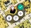
Wikimaps Warper
edit- OAuth login from Wikimedia Commons, OpenStreetMap or GitHub
- Search of georeferenced maps based on location
- Georeferencing by adding control points to an old map and the current map
- Masking maps to display only the map area
- Compiling map sheets to mosaics
- Exporting georeferenced maps as GeoTiff, rectified PNG, KML, WMS url and tiles url
- iD editor for OpenHistoricalMap
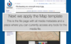
Map template to accommodate map data
editWhat we are just releasing or working on
edit- Batch importing maps to Wikimaps Warper
- Importing a category of maps from Wikimedia Commons to Wikimaps Warper
- Importing a batch of georeferencing data to Wikimaps Warper via csv
- Single map georeferencing data import
- Metadata batch editing tool that allows preparing maps batches for Wikimedia Commons via GWToolset, and other repositories
Project goals: What we want to work on now
editBackend
editThe Warper code will be refactored. User interface is separated from computation to allow more versatile use of the software. Operations inside the code are also separated to make possible developing individual parts separately.
New functions will be added. Mass import of already rectified maps will come handy to GLAM users and can be made part of maps uploads. Category imports will be enabled. Developing the new functionalities will start before the project.
The API will be enhanced to be the primary means of operating the software.
Front end
editAfter this stage the project will be ready for the next phase where user interfaces will be remade. We decided to do this in steps because of time constraints, and to assure that the backend is ready when the front end is made.
Integrations
editWikimedia Finland has an ongoing project for processing metadata for Commons uploads. Warper upload will be made an option in it.
We are looking for Commons volunteers to participate in Commons integrations, coding gadgets and templates. Linking with Wikidata will be a future direction.
Design
editDesign decisions will be based on earlier work in the Wikimaps project, and updated to reflect development in sister software such as the OSM iD editor.
Project plan
editActivities
editThe project concentrates on coding. Volunteers are invited to join the process.
Tim Waters will work on backend, Albin Larsson on front end and Ari Häyrinen on integrations. Susanna Ånäs will work with design issues and coordination. Only the backend will be developed in this project phase, but the participants coordinate development together.
Budget
editThe sums are assumed to exclude taxes. The figures need to be revised, if employer side costs or VAT need to be included.
| weeks | @ | sum | |
| Backend | 4 | 1 000 € | 4 000 € |
| Front end consultation | 1 | 1 000 € | 1 000 € |
| Integrations consultation | 1 | 1 000 € | 1 000 € |
| Coordination, design | 1 | 1 000 € | 1 000 € |
| Administrative costs | 500 € | ||
| 7 500 € |
Community engagement
editCommunity members are invited to discuss choices and pick up tasks if needed, and reflect on the development version during the process.
Sustainability
editContributing to developing the project will be made easier through this project. Considerably more maps will be added and the need for new kinds of tools will become evident. Developers have a continuing interest in the tools and are not likely to abandon the tool after development. The effort ties into the OpenHistoricalMap initiative and serves that community reciprocally.
Measures of success
editNeed target-setting tips? Note: in addition to your project-specific measures of success, you will also be asked to report on some Global Metrics at the end of your final report. Please keep this in mind as you plan, and we'll support you as you begin your project.
- 3 GLAM partners willing to conduct maps mass uploads to Commons and the Wikimaps Warper
- 1 or more new active developer volunteers joining the project
- At least one Commons developer participating in development
Get involved
editParticipants
edit- Tim Waters - back end
- Tim is the original developer of the MapWarper software. It was originally created for the New York Public Library, where it serves thousands of openly available maps. The open source code has spawned MapWarpers around the globe.
- Albin Larsson - front end
- Albin Larsson has worked on the iD editor for OpenHistoricalMap, a sister project for the Wikimaps project. He has made a proposal for a linked data approach to OpenHistoricalMap data and created a prototype of modelling historical buildings in 3D.
- Ari Häyrinen - integrations
- Ari Häyrinen is developing a metadata enhancement tool to be used with GLAM mass uploads in a Wikimedia Finland project. The project will link between copies of files in different repositories to take advantage of spatial mapping possibilities offered by some of them.
- Susanna Ånäs - coordination, design
- Susanna has run the Wikimaps project and network over a two-year period. She will contribute to the design aspects, but mainly her task is to facilitate communication and participation in the project.
- Volunteer Icon design, UI design, QA Todrobbins (talk) 21:15, 5 October 2015 (UTC)
Community Notification
editPlease paste links below to where relevant communities have been notified of your proposal, and to any other relevant community discussions. Need notification tips?
Below are the principal communities to be notified. Each one will be checked when notified:
- The Wikimaps community (Facebook, mailing list)
- Wikimedia maps community (maps-l)
- OpenHistoricalMap community (mailing list)
- Wikimedia GLAM community (mailing list)
All ![]() Done, Susannaanas (talk) 17:16, 9 October 2015 (UTC)
Done, Susannaanas (talk) 17:16, 9 October 2015 (UTC)
Endorsements
editDo you think this project should be selected for an Individual Engagement Grant? Please add your name and rationale for endorsing this project in the list below. (Other constructive feedback is welcome on the talk page of this proposal).
- Good mapping tools are ever more important on Wikipedia. I love this tool, which really helps to connect past and present maps. Making this tool more modular and versatile will help to expand its usage. Erik Zachte (talk) 12:52, 4 October 2015 (UTC)
- Community member: add your name and rationale here.
- The Warper is immensely helpful when contributing to Open Historical Map, which in turn provides much-needed historical basemap layers for the WikiWar Project:
http://wikiwar.net Bertdeb (talk) 17:10, 4 October 2015 (UTC)
- We really need optimal multimedia tools for illustrating Wikipedia, and since so much of the material revolves around historical topics, complex mapping tools for working with historical maps seem like a well needed part of this.Sadads (talk) 12:59, 5 October 2015 (UTC)
- I'm thrilled to see a quality map warper being developed by the Wikimaps project. It's an exciting time to be a digital humanist! Todrobbins (talk) 21:14, 5 October 2015 (UTC)
- gostei muito disso. Anitohandatchikete (talk) 13:38, 9 October 2015 (UTC)
 Support I think it would be great to have this. I was working earlier today with some old maps on Wikipedia and was thinking how difficult it is to work with them onwiki. --Jane023 (talk) 15:25, 25 October 2015 (UTC)
- Support. This should be a tool which unlock s new ways of using maps. Yes please. Filceolaire (talk) 23:17, 25 December 2015 (UTC)