File:TopoLuneplate fertig.svg

Size of this PNG preview of this SVG file: 800 × 600 pixels. Other resolutions: 320 × 240 pixels | 640 × 480 pixels | 1,024 × 768 pixels | 1,280 × 960 pixels | 2,560 × 1,920 pixels | 1,355 × 1,016 pixels.
Original file (SVG file, nominally 1,355 × 1,016 pixels, file size: 647 KB)
Summary
| Description |
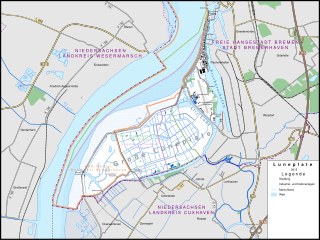
English: Map of Luneplate
Deutsch: Karte der Luneplate mit Schutzgebieten und Details auf der Luneplate, Umfeld weniger detailliert dargestellt. Entstanden aus dem Karten-Kurs in Hamburg am 21./22.11.2015. Quelle sind neben OSM die amtlichen Veröffentlichungen zu den Schutzgebieten. |
| Date | |
| Source | Own work, Openstreetmap |
| Author | Don-kun, Openstreetmap-Beitragende |
| Other versions | File:Karte Luneplate 2015.png |
Licensing
This file is licensed under the Creative Commons Attribution-Share Alike 4.0 International license.
- You are free:
- to share – to copy, distribute and transmit the work
- to remix – to adapt the work
- Under the following conditions:
- attribution – You must give appropriate credit, provide a link to the license, and indicate if changes were made. You may do so in any reasonable manner, but not in any way that suggests the licensor endorses you or your use.
- share alike – If you remix, transform, or build upon the material, you must distribute your contributions under the same or compatible license as the original.
File history
Click on a date/time to view the file as it appeared at that time.
| Date/Time | Thumbnail | Dimensions | User | Comment | |
|---|---|---|---|---|---|
| current | 21:29, 26 November 2015 | | 1,355 × 1,016 (647 KB) | Don-kun | {{Information |Description ={{en|1=Map of Luneplate}} {{de|1=Karte der Luneplate mit Schutzgebieten und Details auf der Luneplate, Umfeld weniger detailliert dargestellt. Entstanden aus dem Karten-Kurs in Hamburg am 21./22.11.2015.}} |Source... |
File usage
The following 2 pages use this file: