File:Spain, Catalonia, Muntanyola, Múnter.JPG

Size of this preview: 800 × 531 pixels. Other resolutions: 320 × 213 pixels | 640 × 425 pixels | 1,024 × 680 pixels | 1,280 × 850 pixels | 2,144 × 1,424 pixels.
Original file (2,144 × 1,424 pixels, file size: 728 KB, MIME type: image/jpeg)
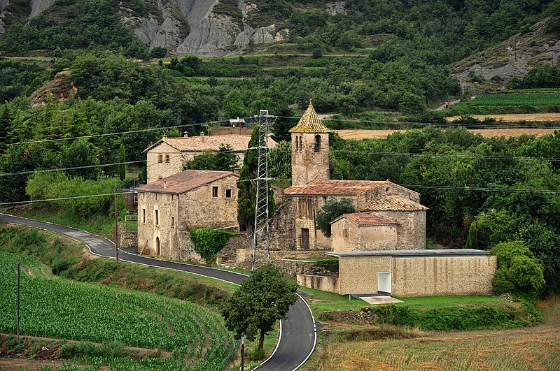
This is a photo of a building indexed in the Catalan heritage register as Bé Cultural d'Interès Local (BCIL) under the reference IPA-23129 (Església de Sant Esteve de Múnter). |
This is a photo of a building indexed in the Catalan heritage register as Bé Cultural d'Interès Local (BCIL) under the reference IPA-23131 (Rectoria de Sant Esteve de Múnter). |
Summary
| Description |
Català: Església parroquial de Sant Esteve de Múnter (municipi Muntanyola, comarca Osona, Catalunya, Espanya). Forma un petit conjunt amb una masia i la rectoria. La rectoria és una gran masia catalana. El temple parroquial és d'origen romànic, però va ser molt transformat el segle XVII.
Nederlands: Parochiekerk van St. Stefanus in het gehucht Múnter (gemeente Muntanyola, district/comarca Osona, Catalonië, Spanje). De kerk vormt een kleine groep met een huis en de pastorie. De pastorie is een grote Catalaanse boerderij. De kerk is van Romaanse oorsprong, maar is in de 17e eeuw sterk verbouwd.
English: Parish Church of St. Stephen in the hamlet of Múnter (Muntanyola municipality, county Osona, Catalonia, Spain). The church forms a small group with a house and the rectory. The rectory is a large Catalan farmhouse. The church is of Romanesque origin, but was transformed in the 17th century.
Español: Iglesia parroquial de San Esteban de Múnter (municipio Muntanyola, comarca Osona, Cataluña, España). Forma un pequeño conjunto con una masía y la rectoría. La rectoría es una gran masía catalana. El templo parroquial es de origen románico, pero fue muy transformado el siglo XVII. |
| Date | |
| Source | Own work |
| Author | Vincent van Zeijst |
| Object location | | View this and other nearby images on: OpenStreetMap |
|---|
| Camera location | | View this and other nearby images on: OpenStreetMap |
|---|
Licensing
I, the copyright holder of this work, hereby publish it under the following license:
This file is licensed under the Creative Commons Attribution-Share Alike 3.0 Unported license.
- You are free:
- to share – to copy, distribute and transmit the work
- to remix – to adapt the work
- Under the following conditions:
- attribution – You must give appropriate credit, provide a link to the license, and indicate if changes were made. You may do so in any reasonable manner, but not in any way that suggests the licensor endorses you or your use.
- share alike – If you remix, transform, or build upon the material, you must distribute your contributions under the same or compatible license as the original.
File history
Click on a date/time to view the file as it appeared at that time.
| Date/Time | Thumbnail | Dimensions | User | Comment | |
|---|---|---|---|---|---|
| current | 21:17, 10 February 2012 | | 2,144 × 1,424 (728 KB) | Loranchet | {{Information |Description ={{ca|1=Església parroquial de Sant Esteve de Múnter (municipi Muntanyola, comarca Osona, Catalunya, Espanya). Forma un petit conjunt amb una masia i la rectoria. La rectoria és una gran masia catalana. El temple parroquia |
File usage
The following page uses this file:
Global file usage
The following other wikis use this file:
- Usage on ar.wikipedia.org
- Usage on ast.wikipedia.org
- Usage on ca.wikipedia.org
- Usage on ceb.wikipedia.org
- Usage on ce.wikipedia.org
- Usage on diq.wikipedia.org
- Usage on en.wikipedia.org
- Usage on es.wikipedia.org
- Usage on eu.wikipedia.org
- Usage on fr.wikipedia.org
- Usage on gl.wikipedia.org
- Usage on hu.wikipedia.org
- Usage on hy.wikipedia.org
- Usage on ia.wikipedia.org
- Usage on it.wikipedia.org
- Usage on la.wikipedia.org
- Usage on lld.wikipedia.org
- Usage on lmo.wikipedia.org
- Usage on pl.wikipedia.org
- Usage on pt.wikipedia.org
- Usage on ro.wikipedia.org
- Usage on ru.wikipedia.org
- Usage on sv.wikipedia.org
- Usage on tt.wikipedia.org
- Usage on uz.wikipedia.org
- Usage on vec.wikipedia.org
- Usage on www.wikidata.org