File:Manilaairportmap.png
Size of this preview: 600 × 600 pixels. Other resolutions: 240 × 240 pixels | 480 × 480 pixels | 768 × 768 pixels | 1,024 × 1,024 pixels | 2,368 × 2,368 pixels.
Original file (2,368 × 2,368 pixels, file size: 573 KB, MIME type: image/png)
Summary
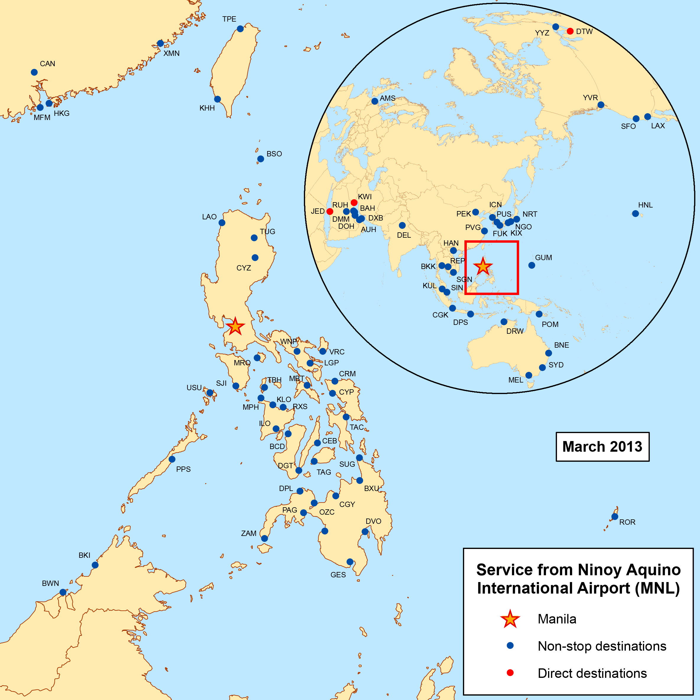
| Description | This is a route map for Ninoy Aquino International Airport as of January 2008. Map is an Azimuthal equidistant projection centered on the airport so straight lines from Manila are along great circle routes. |
| Date | |
| Source | self-made, data is from individual airline websites. |
| Author | Kmusser |
Licensing
I, the copyright holder of this work, hereby publish it under the following license:
This file is licensed under the Creative Commons Attribution-Share Alike 2.5 Generic license.
- You are free:
- to share – to copy, distribute and transmit the work
- to remix – to adapt the work
- Under the following conditions:
- attribution – You must give appropriate credit, provide a link to the license, and indicate if changes were made. You may do so in any reasonable manner, but not in any way that suggests the licensor endorses you or your use.
- share alike – If you remix, transform, or build upon the material, you must distribute your contributions under the same or compatible license as the original.
File history
Click on a date/time to view the file as it appeared at that time.
| Date/Time | Thumbnail | Dimensions | User | Comment | |
|---|---|---|---|---|---|
| current | 03:06, 21 January 2013 | | 2,368 × 2,368 (573 KB) | Kmusser | Updated destinations |
| 23:27, 27 January 2011 |  | 1,000 × 1,001 (473 KB) | Kmusser | updated destinations | |
| 16:39, 7 January 2009 |  | 1,000 × 1,000 (442 KB) | Kmusser | more fixes | |
| 18:10, 6 January 2009 |  | 1,000 × 1,000 (444 KB) | Kmusser | updated destinations | |
| 17:20, 22 January 2008 |  | 1,000 × 1,000 (474 KB) | Kmusser | Added destinations | |
| 15:36, 3 January 2008 |  | 1,000 × 1,000 (406 KB) | Kmusser | {{Information |Description=This is a route map for Ninoy Aquino International Airport as of January 2008. Map is an Azimuthal equidistant projection centered on the airpo |
File usage
The following 2 pages use this file:
Global file usage
The following other wikis use this file:
- Usage on en.wikipedia.org
- Usage on vi.wikipedia.org