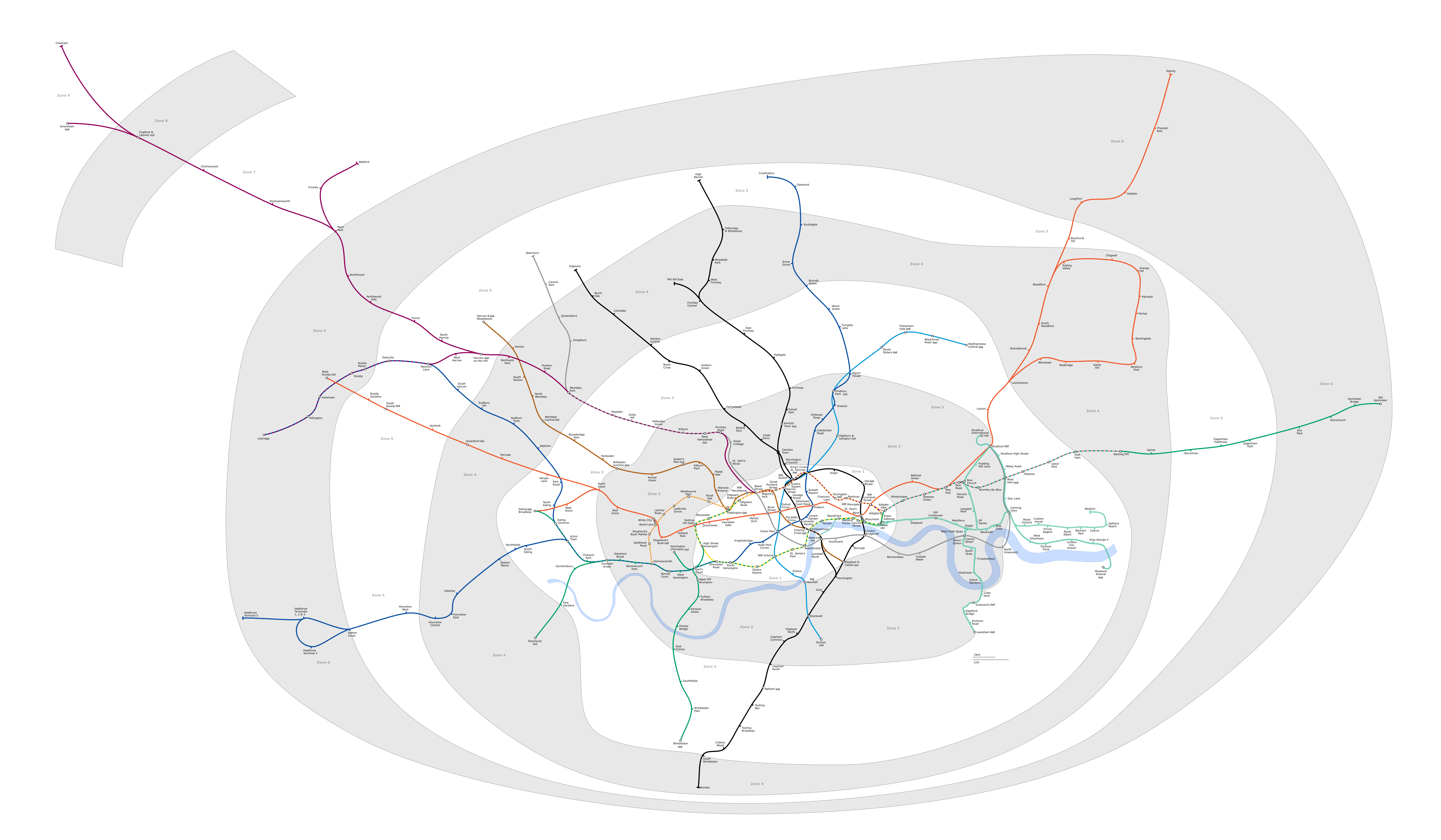
File:London Underground full map.png
Size of this preview: 800 × 467 pixels. Other resolutions: 320 × 187 pixels | 640 × 373 pixels | 1,024 × 597 pixels | 1,280 × 747 pixels | 2,560 × 1,493 pixels | 6,000 × 3,500 pixels.
Original file (6,000 × 3,500 pixels, file size: 1.36 MB, MIME type: image/png)
Generated as part of the London Underground geographic maps project by software written by ed g2s • talk and James D. Forrester utilising GPS data.
NB: Routes between stations are interpolated and may not be geographically accurate

|
Permission is granted to copy, distribute and/or modify this document under the terms of the GNU Free Documentation License, Version 1.2 or any later version published by the Free Software Foundation; with no Invariant Sections, no Front-Cover Texts, and no Back-Cover Texts. A copy of the license is included in the section entitled GNU Free Documentation License. |
| This file is licensed under the Creative Commons Attribution-Share Alike 3.0 Unported license. | ||
| ||
| This licensing tag was added to this file as part of the GFDL licensing update. |
This file is licensed under the Creative Commons Attribution-Share Alike 2.5 Generic, 2.0 Generic and 1.0 Generic license.
- You are free:
- to share – to copy, distribute and transmit the work
- to remix – to adapt the work
- Under the following conditions:
- attribution – You must give appropriate credit, provide a link to the license, and indicate if changes were made. You may do so in any reasonable manner, but not in any way that suggests the licensor endorses you or your use.
- share alike – If you remix, transform, or build upon the material, you must distribute your contributions under the same or compatible license as the original.
Upload log
Latest versions of this file are uploaded from wts.wikivoyage-old.org.
The original description page was here. All following user names refer to wts.wikivoyage-old.
org:
- 2010-02-11 19:08:44 4100×2374 (1,076,793 bytes) (WT-shared) Peterfitzgerald attempted fix (Import from wikitravel.org/shared)
- 2009-12-20 21:41:21 4000×2312 (827,759 bytes) (WT-shared) Peterfitzgerald increase resolution (Import from wikitravel.org/shared)
- 2009-12-20 00:59:42 3000×1734 (571,486 bytes) (WT-shared) Peterfitzgerald == Summary == {{Imagecredit|credit=[[:wmc:User:DavidCane]], [[:wmc:User:Ed g2s]], Peter Fitzgerald|captureDate=19 December 2009|location=Lon (Import from wikitravel.org/shared)
File history
Click on a date/time to view the file as it appeared at that time.
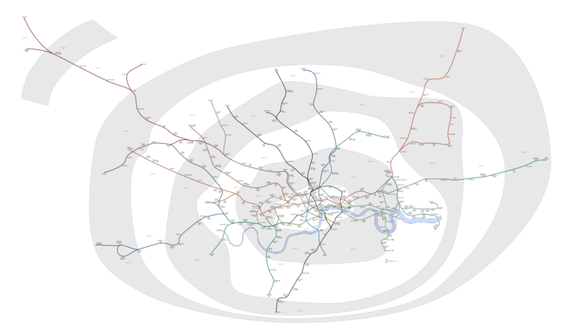
| Date/Time | Thumbnail | Dimensions | User | Comment | |
|---|---|---|---|---|---|
| current | 23:23, 4 February 2018 | | 6,000 × 3,500 (1.36 MB) | DavidCane | Amend to correspond to svg version |
| 13:04, 8 October 2015 |  | 6,000 × 3,500 (1.1 MB) | RokerHRO | optipng -o7 -i0 -zc1-9 -zm1-9 -zs0-3 -f0-5 → 19.47% decrease | |
| 03:26, 12 August 2014 |  | 6,000 × 3,500 (1.36 MB) | Jc86035 | Updated again | |
| 12:07, 8 August 2014 |  | 6,000 × 3,500 (1.35 MB) | Jc86035 | again, updated from SVG version | |
| 15:15, 3 December 2013 |  | 6,000 × 3,500 (1.35 MB) | Jc86035 | Updated from SVG at File:London Underground full map.svg | |
| 08:42, 22 November 2012 |  | 4,000 × 2,320 (274 KB) | Atsirlin | Reverted to version as of 01:42, 6 January 2007: OK, importing new versions was a bad idea... | |
| 08:32, 22 November 2012 |  | 4,100 × 2,374 (1.03 MB) | OgreBot | (BOT): Uploading old version of file from wts.wikivoyage-old; originally uploaded on 2010-02-11 19:08:44 by (WT-shared) Peterfitzgerald | |
| 08:32, 22 November 2012 |  | 4,000 × 2,312 (808 KB) | OgreBot | (BOT): Uploading old version of file from wts.wikivoyage-old; originally uploaded on 2009-12-20 21:41:21 by (WT-shared) Peterfitzgerald | |
| 08:32, 22 November 2012 |  | 3,000 × 1,734 (558 KB) | OgreBot | (BOT): Uploading old version of file from wts.wikivoyage-old; originally uploaded on 2009-12-20 00:59:42 by (WT-shared) Peterfitzgerald | |
| 01:42, 6 January 2007 |  | 4,000 × 2,320 (274 KB) | Ed g2s | new zone 4 boundary |
File usage
The following page uses this file:
Global file usage
The following other wikis use this file:
- Usage on da.wikipedia.org
- Usage on en.wikipedia.org
- Usage on en.wikivoyage.org
- Usage on es.wikipedia.org
- Usage on fr.wikivoyage.org
- Usage on he.wikipedia.org
- Usage on hi.wikipedia.org
- Usage on hu.wikipedia.org
- Usage on ja.wikipedia.org
- Usage on ko.wikipedia.org
- Usage on nap.wikipedia.org
- Usage on nl.wikipedia.org
- Acton Town (metrostation)
- Alperton (metrostation)
- Amersham (metrostation)
- Arnos Grove (metrostation)
- Dagenham East (metrostation)
- Debden (metrostation)
- Dagenham Heathway (metrostation)
- Fairlop (metrostation)
- Finchley Central (metrostation)
- Ickenham (metrostation)
- Station Balham
- Barkingside (metrostation)
- Becontree (metrostation)
- Boston Manor (metrostation)
- Bounds Green (metrostation)
- Brent Cross (metrostation)
- Buckhurst Hill (metrostation)
- Burnt Oak (metrostation)
- Oakwood (metrostation)
- Osterley (metrostation)
- Stanmore (metrostation)
- Gants Hill (metrostation)
- Grange Hill (metrostation)
- Canons Park (metrostation)
- Station Chalfont & Latimer
- Chesham (metrostation)
- Chigwell (metrostation)
- Station Chorleywood
- Cockfosters (metrostation)
- Colindale (metrostation)
- Colliers Wood (metrostation)
- Croxley (metrostation)
- Custom House for ExCeL
- Cyprus (metrostation)
- Queensbury (metrostation)
View more global usage of this file.