File:France map Lambert-93 with regions and departments-occupation-fr.svg

Size of this PNG preview of this SVG file: 632 × 600 pixels. Other resolutions: 253 × 240 pixels | 506 × 480 pixels | 809 × 768 pixels | 1,079 × 1,024 pixels | 2,158 × 2,048 pixels | 2,000 × 1,898 pixels.
Original file (SVG file, nominally 2,000 × 1,898 pixels, file size: 902 KB)
Summary
| Description |
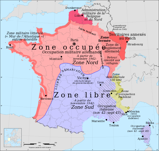
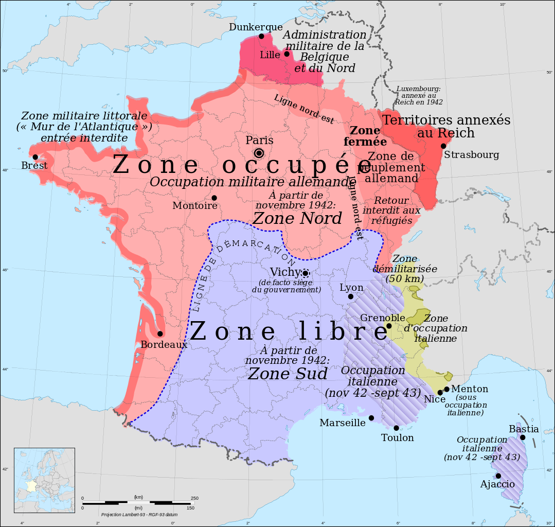
Français : Carte de France : les zones françaises occupées pendant la Seconde Guerre mondiale, version française
English: Occupation zones of France during the Second World War, French version
Esperanto: Okupitaj zonoj de Francio dum la Dua Mondmilito, franclingva versio |
| Date | |
| Source |
Own work *Source of data: NGDC World Data Bank II (public domain)* Image:France map Lambert-93 with regions and departments-blank.svg |
| Author |
Eric Gaba (Sting - fr:Sting) for original blank map Rama for zones |
| Permission (Reusing this file) |
GFDL / Attribution and Share-Alike required |
| Other versions |
Derivative works of this file: versions
|
| SVG development |


| Camera location | | View this and other nearby images on: OpenStreetMap |
|---|
Licensing
I, the copyright holder of this work, hereby publish it under the following licenses:

|
Permission is granted to copy, distribute and/or modify this document under the terms of the GNU Free Documentation License, Version 1.2 or any later version published by the Free Software Foundation; with no Invariant Sections, no Front-Cover Texts, and no Back-Cover Texts. A copy of the license is included in the section entitled GNU Free Documentation License. |
This file is licensed under the Creative Commons Attribution-Share Alike 4.0 International, 3.0 Unported, 2.5 Generic, 2.0 Generic and 1.0 Generic license.
- You are free:
- to share – to copy, distribute and transmit the work
- to remix – to adapt the work
- Under the following conditions:
- attribution – You must give appropriate credit, provide a link to the license, and indicate if changes were made. You may do so in any reasonable manner, but not in any way that suggests the licensor endorses you or your use.
- share alike – If you remix, transform, or build upon the material, you must distribute your contributions under the same or compatible license as the original.
You may select the license of your choice.
File history
Click on a date/time to view the file as it appeared at that time.
| Date/Time | Thumbnail | Dimensions | User | Comment | |
|---|---|---|---|---|---|
| current | 14:43, 30 August 2013 | | 2,000 × 1,898 (902 KB) | Gégène | Marseille et Lille étaient mal placées. Conseil: revoir les autres versions de cette carte dans d'autres langues. |
| 22:33, 8 March 2011 |  | 2,000 × 1,898 (902 KB) | Rama | Closed zone and North-East line | |
| 09:34, 18 July 2010 |  | 2,000 × 1,898 (900 KB) | Rama | "gouvernEment" | |
| 16:27, 28 November 2008 |  | 2,000 × 1,898 (900 KB) | Rama | ||
| 15:20, 28 November 2008 |  | 2,000 × 1,898 (898 KB) | Rama | ||
| 08:45, 28 November 2008 |  | 2,000 × 1,898 (898 KB) | Rama | ||
| 23:20, 27 November 2008 |  | 2,000 × 1,898 (901 KB) | Rama | ||
| 23:05, 27 November 2008 |  | 2,000 × 1,898 (899 KB) | Rama | ||
| 22:44, 27 November 2008 |  | 2,000 × 1,898 (898 KB) | Rama | ||
| 22:42, 27 November 2008 |  | 2,000 × 1,898 (898 KB) | Rama | {{Information |Description= |Source= |Date= |Author= |Permission= |other_versions= }} |
File usage
The following page uses this file:
Global file usage
The following other wikis use this file:
- Usage on br.wikipedia.org
- Usage on ca.wikipedia.org
- Usage on cy.wikipedia.org
- Usage on de.wikipedia.org
- Usage on el.wikipedia.org
- Usage on fa.wikipedia.org
- Usage on fi.wikipedia.org
- Usage on fr.wikipedia.org
- France
- Radio France internationale
- Histoire de la Drôme
- Zone occupée
- Zone libre
- Michel Hollard
- Bugey
- Louhans
- Résistance intérieure française
- André Girard (peintre)
- Relations entre l'Allemagne et la France
- Maquis de l'Ain et du Haut-Jura
- Histoire de l'Occitanie pendant le régime de Vichy
- Histoire des Basques
- Alliance (réseau)
- Armistice du 22 juin 1940
- Zone interdite (Seconde Guerre mondiale)
- Discussion utilisateur:Rama/archive 4
- La Ligne de démarcation
- Histoire de Grenoble
- Histoire de l'Occitanie
- Bataille de France
- Histoire de La Rochelle
- Armistice du 24 juin 1940
- Camp de concentration d'Argelès-sur-Mer
- Libération de Guéret
- Secteur fortifié du Dauphiné
- Saint-Barthélemy grenobloise
- Irrédentisme italien en Corse
- Marc Chevalier (chanteur)
- Henry Castaing
- Histoire du Bugey
- Lyon pendant la Seconde Guerre mondiale
- Transit (roman)
- Résistance en Mayenne
- Utilisateur:Sboot/Brouillon
- Histoire du bassin minier du Nord-Pas-de-Calais
- Utilisateur:SashiRolls/Livres/Résistance
View more global usage of this file.