File:Dothan Regional Airport diagram.png

Size of this preview: 412 × 600 pixels. Other resolutions: 165 × 240 pixels | 330 × 480 pixels | 528 × 768 pixels | 703 × 1,024 pixels | 1,570 × 2,285 pixels.
Original file (1,570 × 2,285 pixels, file size: 330 KB, MIME type: image/png)
Summary
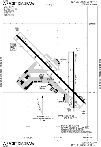
| Description | FAA diagram for Dothan Regional Airport (FAA: DHN, ICAO: KDHN) in Dothan, Alabama, United States. |
| Date | 12 October 2006 |
| Source | http://naco.faa.gov/d-tpp/0610/00123AD.PDF (effective 28 SEP 2006 to 26 OCT 2006). Note: this URL changes monthly, see airport article's external links for a link to the current FAA diagram. |
| Author | National Aeronautical Charting Office (NACO), a department of the Federal Aviation Administration (FAA) in the United States. |
| Permission (Reusing this file) |
Public Domain |
Licensing
This image or file is a work of a Federal Aviation Administration employee, taken or made as part of that person's official duties. As a work of the U.S. federal government, the image is in the public domain in the United States.
|
 |
File history
Click on a date/time to view the file as it appeared at that time.
| Date/Time | Thumbnail | Dimensions | User | Comment | |
|---|---|---|---|---|---|
| current | 17:41, 12 October 2006 | | 1,570 × 2,285 (330 KB) | Epolk | {{Information |Description= |Source=http://www.naco.faa.gov/digital_tpp_search.asp?ver=0610&eff=09-28-2006&end=10-26-2006&fldIdent=DHN&fld_ident_type=FAA&st=&fldAPName=&fldVol=&fldShowADOnly=Y&submit1=Search |Date=September 28, 2006 |Author=FAA |Permissio |
File usage
The following page uses this file:
Global file usage
The following other wikis use this file:
- Usage on arz.wikipedia.org
- Usage on ceb.wikipedia.org
- Usage on id.wikipedia.org
- Usage on www.wikidata.org