File:Arab World Green.svg

Size of this PNG preview of this SVG file: 800 × 406 pixels. Other resolutions: 320 × 162 pixels | 640 × 325 pixels | 1,024 × 520 pixels | 1,280 × 650 pixels | 2,560 × 1,299 pixels | 940 × 477 pixels.
Original file (SVG file, nominally 940 × 477 pixels, file size: 404 KB)
Summary
| Description |
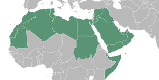
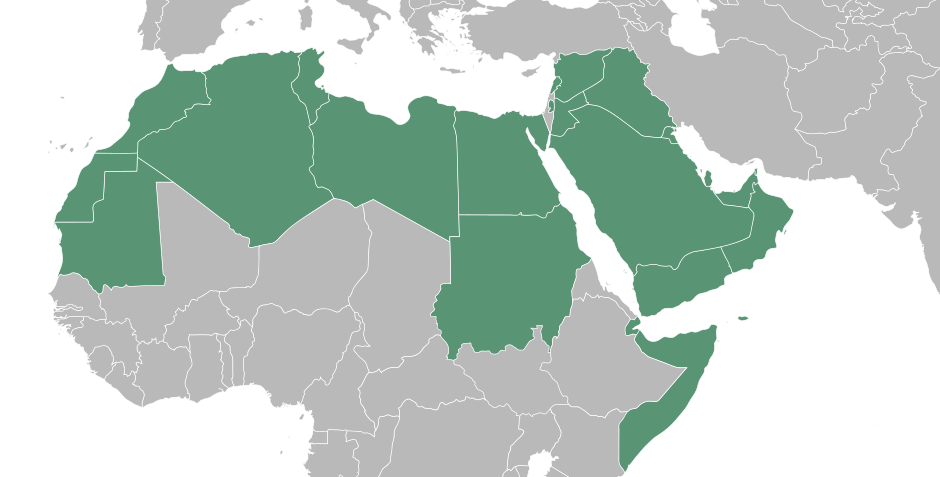
English: A map showing a portion of the Islamic world, North African country's are inhabited by the Amazigh an minority among them identified them self as Arab, in many cases it's what the feel despite not having an Semitic Middle eastern DNA. Egyptians are not Arabian either, but you have to understand they became Arab by culture. Last but not least the Middle East where the Arab originated from. The Islamic world has so many different race's that it is impossible to talk about an Arab world while the majority of the Muslims is not of Arab decent. The Islamic world is very cultural and racial diverse. It is their religion and spiritual bond that comes with it what connects them. Because of that, it's more appropriate and polite to talk about the Islamic world because that is what connects them. Besides that there is no Arabian Empire that rules over the whole Islamic world.
العربية: خريطة العالم العرب
ქართული: არაბული სამყაროს რუკა |
| Date | |
| Source | |
| Author | T.seppelt |
| Other versions |
|
| SVG development |

Licensing
| I, the copyright holder of this work, release this work into the public domain. This applies worldwide. In some countries this may not be legally possible; if so: I grant anyone the right to use this work for any purpose, without any conditions, unless such conditions are required by law. |
File history
Click on a date/time to view the file as it appeared at that time.
| Date/Time | Thumbnail | Dimensions | User | Comment | |
|---|---|---|---|---|---|
| current | 10:49, 3 September 2022 | | 940 × 477 (404 KB) | SahinBasaran | Reverted to version as of 02:46, 3 September 2022 (UTC) |
| 10:49, 3 September 2022 |  | 1,920 × 974 (311 KB) | SahinBasaran | Reverted to version as of 21:05, 2 September 2022 (UTC) | |
| 10:48, 3 September 2022 |  | 2,400 × 1,218 (440 bytes) | SahinBasaran | Reverted to version as of 21:00, 2 September 2022 (UTC) | |
| 02:46, 3 September 2022 |  | 940 × 477 (404 KB) | M.Bitton | Reverted to version as of 03:34, 21 February 2016 (UTC): please don't perform tests on stable maps | |
| 21:05, 2 September 2022 |  | 1,920 × 974 (311 KB) | SahinBasaran | Added Israel, Malta and Somaliland. | |
| 21:00, 2 September 2022 |  | 2,400 × 1,218 (440 bytes) | SahinBasaran | Added Israel, Malta and Somaliland. | |
| 03:34, 21 February 2016 |  | 940 × 477 (404 KB) | Turnless | Fix format | |
| 20:45, 11 April 2015 |  | 940 × 477 (431 KB) | T.seppelt | {{Information |Description ={{en|1=a map of the Arab World}} |Source ={{Attrib |1=BlankMap-Middle East.svg |2=NuclearVacuum }} |Author =T.seppelt |Date =2015-04-11 |Permission = |other_versions =[[:Fi... |
File usage
The following 2 pages use this file:
Global file usage
The following other wikis use this file:
- Usage on af.wikipedia.org
- Usage on als.wikipedia.org
- Usage on arc.wikipedia.org
- Usage on ar.wikipedia.org
- Usage on arz.wikipedia.org
- Usage on az.wiktionary.org
- Usage on bg.wikipedia.org
- Usage on bn.wikipedia.org
- Usage on bs.wikipedia.org
- Usage on de.wikipedia.org
- Usage on de.wikinews.org
- Portal:Tunesien
- Portal:Irak
- Portal:Libanon
- Portal:Syrien
- Portal:Sudan
- Portal:Somalia
- Portal:Ägypten
- Portal:Saudi-Arabien
- Portal:Jemen
- Portal:Vereinigte Arabische Emirate
- Wikinews:Archiv/Hauptseite/2011/02
- Portal:Arabische Welt
- Vorlage:Portalnavigationsleiste Arabische Welt
- Wikinews:Pressestammtisch/Archiv/2011/Februar
- Portal:Libyen
- Usage on en.wikipedia.org
- Usage on en.wiktionary.org
- Usage on es.wikipedia.org
- Usage on fa.wikipedia.org
- Usage on fa.wikiquote.org
- Usage on fr.wikipedia.org
- Usage on fy.wikipedia.org
- Usage on gl.wikipedia.org
- Usage on he.wikipedia.org
- Usage on hu.wikipedia.org
- Usage on hy.wikipedia.org
View more global usage of this file.