File:Озеро Дус-Холь вечером. Тес-Хемский кожуун.jpg

Size of this preview: 800 × 475 pixels. Other resolutions: 320 × 190 pixels | 640 × 380 pixels | 1,024 × 608 pixels | 1,280 × 760 pixels | 2,560 × 1,521 pixels | 4,504 × 2,676 pixels.
Original file (4,504 × 2,676 pixels, file size: 5.09 MB, MIME type: image/jpeg)
Summary
| Description |
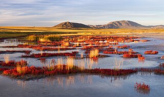
Русский: Республика Тыва, 150 км к югу от города Кызыл
English: 150 km south Kyzyl city. The Tyva Republic. Russian Federation.
Español: Paisaje en la reserva de la biosfera de la depresión de Ubsunur, 150 km al sur de la ciudad de Kizil, Tuvá, Rusia.
Polski: Krajobraz w Rezerwacie Biosfery „Kotlina Uwska”, około 150 km na południe od miasta Kyzył w Republice Tuwy, w Rosji.
Čeština: Krajina v biosférické rezervaci v Uvsunurské kotlině, Tuvinská republika, jižní Sibiř, Rusko.
Nederlands: Het biosfeerreservaat Bekken van de Uvs Nuur op de grens van Mongolië en de autonome Russische republiek Toeva
|
| Date | |
| Source | Own work |
| Author | Александр Лещёнок |
| Object location | | View this and other nearby images on: OpenStreetMap |
|---|
This image was uploaded as part of Wiki Loves Earth 2015.
|
 |
Assessment
|
This image was selected as picture of the day on Wikimedia Commons for 25 August 2018. It was captioned as follows: Other languages:
Čeština: Krajina v biosférické rezervaci v Uvsunurské kotlině, Tuvinská republika, jižní Sibiř, Rusko. Nederlands: Het biosfeerreservaat Bekken van de Uvs Nuur op de grens van Mongolië en de autonome Russische republiek Toeva |
This image was selected as picture of the day on Vietnamese Wikipedia for 12 June 2023.
|
Licensing
I, the copyright holder of this work, hereby publish it under the following license:
This file is licensed under the Creative Commons Attribution-Share Alike 4.0 International license.
- You are free:
- to share – to copy, distribute and transmit the work
- to remix – to adapt the work
- Under the following conditions:
- attribution – You must give appropriate credit, provide a link to the license, and indicate if changes were made. You may do so in any reasonable manner, but not in any way that suggests the licensor endorses you or your use.
- share alike – If you remix, transform, or build upon the material, you must distribute your contributions under the same or compatible license as the original.
File history
Click on a date/time to view the file as it appeared at that time.
| Date/Time | Thumbnail | Dimensions | User | Comment | |
|---|---|---|---|---|---|
| current | 17:10, 17 June 2015 | | 4,504 × 2,676 (5.09 MB) | Александр Лещёнок | Полноразмерный файл |
| 05:36, 31 May 2015 |  | 1,800 × 1,069 (904 KB) | Александр Лещёнок | User created page with UploadWizard |
File usage
The following 8 pages use this file:
Global file usage
The following other wikis use this file:
- Usage on be-tarask.wikipedia.org
- Usage on be.wikipedia.org
- Usage on crh.wikipedia.org
- Usage on cs.wikipedia.org
- Usage on cv.wikipedia.org
- Usage on en.wikipedia.org
- Mammoth steppe
- Uvs Lake Basin
- List of World Heritage Sites in Russia
- List of World Heritage Sites in Northern and Central Asia
- Beringian wolf
- User:Daniel Mietchen/gallery
- User:Northamerica1000/Topics
- Wood-pasture hypothesis
- User:コルモラン/sandbox/避難所3
- Wikipedia:Featured picture candidates/Uvs Lake Basin
- Wikipedia:Featured picture candidates/November-2021
- Usage on es.wikipedia.org
- Usage on fr.wikipedia.org
- Usage on gl.wikipedia.org
- Usage on hr.wikipedia.org
- Usage on hu.wikipedia.org
- Usage on hy.wikipedia.org
- Usage on incubator.wikimedia.org
- Usage on it.wikipedia.org
- Usage on ka.wikipedia.org
- Usage on ko.wikipedia.org
- Usage on lbe.wikipedia.org
- Usage on lb.wikipedia.org
- Usage on lez.wikipedia.org
- Usage on lt.wikipedia.org
- Usage on mk.wikipedia.org
- Usage on ms.wikipedia.org
- Usage on mt.wikipedia.org
View more global usage of this file.