Talk:WikiMiniAtlas
| Please consider reporting bugs and wishlist items at the WikiMiniAtlas Issue Tracker on GitHub. |
Update: 12:44, 22 August 2007 (UTC) - Server-side update edit
Today's server-side update should make the WMA more responsive (labels should appear at least 3x faster). I rushed this update, as the previous version put quite a bit of strain on the Toolserver. In a nutshell: the maplabels are served as HTML snippets by custom HTTP servers bound to the loopback interface of the Toolserver, for security reasons. Before the update all label retrievals were proxied through a PHP-script, now I'm using mod_rewrite-proxying. This saves a 7Mb process spawn for each tile. --Dschwen 12:44, 22 August 2007 (UTC)
WikiMiniAtlas on en:w edit
In case someone needs to find it, discussion about WikiMiniAtlas on the english Wikipedia apparently took place here. (SEWilco 17:44, 26 August 2007 (UTC))
- And here's the archived link: w:en:MediaWiki_talk:Common.js/Archive_Sep_2007#WikiMiniAtlas. 75.213.67.22 (really, w:en:User:JesseW/not logged in) 20:01, 30 August 2009 (UTC)
The globe icon edit
There has been discussion about the globe icon at en:w:Template talk:coord. Now that the source of it has been identified, discussion has been directed to here. (SEWilco 17:46, 26 August 2007 (UTC))
- After much wandering about, I believe I've found the right page. At the risk of being a pain, I think that there is an issue with the globe. Image:Erioll world.svg is under the GFDL and the image authorship is not available by clicking on the image. I consider myself fairly familiar with wiki formatting and I'm still not sure that I'm at the source of the image. Therefore every occurrence of the clickable globe is a violation of the terms of the image license. - BanyanTree 12:14, 29 September 2007 (UTC)
- What's your suggestion on how to fix this? Would a note on the settings page of the Wikiminiatlas help (a link to the original image, or even an image credit)? Or should a replacement icon be found? --Dschwen 21:01, 29 September 2007 (UTC)
- The only thing that is irritating me a little is that I'm not hell-bent on taking credit for the WikiMiniAtlas, my name isn't stuck anywhere on that map applet, and I believe it has been waaaay more work to program this than draw a globe icon. Well, I guess a license is a license... --Dschwen 21:04, 29 September 2007 (UTC)
Problem(?) in "Washington Monument example" map edit
First, this is a great addition to WP!
When following the link to the WM, opening the map and drilling all the way down, where the White House should be is a link to Dhaka, Bangladesh!? I did a cursory check of both pages and didn't see any inappropriate coords. Where is this coming from?
Again, congrats on a valuable feature. Saintrain 16:23, 27 August 2007 (UTC)
- This has the same underlying issue as the FAQ point about the red dot. Coordinates are extracted and combined from several language versions (using interlanguage links to connect the aricles). So most likely one of the foreign language versions has a broken coordinate (most likely error is the confusion of east and west). But this just gave me the idea of adding the source language of the coordinates as a tooltip to the lables. Stay tuned :-) --Dschwen 16:32, 27 August 2007 (UTC)
- I understand a little better now, thanks. Is there a non-sql interface (even a text file) to Kolossos's or Stefan Kühn's Koordinatenfiles so that I can track down the page(s) in error? Thanks, Saintrain 18:51, 27 August 2007 (UTC).
- Check this out de:Wikipedia:WikiProjekt_Georeferenzierung/Wikipedia-World/en, it is the english project page for the Koordinatenfiles. --Dschwen 09:29, 28 August 2007 (UTC)
Inlined map feature request edit
Would it be possible to add to the API of WikiMiniAtlas to allow a one-time serving of a static image of a map that could be inlined where appropriate? Maybe a template with coord ranges, zoom level, image size, etc? I suppose that would require a separate image file for each instance (proliferating as coords got "adjusted", etc.).
Alternatively, allow a "live" map displayable inline (already "popped-up", sized and not covering text)? Saintrain 16:35, 27 August 2007 (UTC)
- So you want to have a map such as the one on top of w:List of Minnesota state parks be displayed from coordinates in the same article? (SEWilco 19:43, 28 August 2007 (UTC))
- Cool idea! I like that a lot. But as I (poorly, yet) understand how WMA works, it would require a serious redesign of the placename database usage. Ultimately your idea is a great target. (Sooner, actually, or it wouldn't be much use :-)
- What I was thinking was how to improve an article like w:Lake_Tanganyika that has a static, unlabeled image instead of a real map. What I'd like to see is something like: replace the [[Image:...]] with [[WMA:CoordLeft=28 |CoordRight=32 |CoordTop=-9.5 |CoordBottom=-2 |Zoom=5 |250px |Caption |etc |etc}} or equivalent. (Maybe even a <WMA> extension?)
- The only instances of WMA that I've seen "piggyback" on coorX, etc., templates, so always present as a globe icon. I haven't seen it yet (I'm looking) but an inlined, already-popped-up, pre-zoomed WMA map should be feasible. (Yes, I capable, willing, interested and volunteering! If I can just get all the code in one place!) Saintrain 01:17, 29 August 2007 (UTC)
Globe icon causes unfortunate line breaks in en's Infobox Mountain edit
I appreciate the effort that went into the WikiMiniAtlas: in general, it is a nice feature.
en's WikiProject Mountain is having problems, because the extra space used by the globe icon causes odd line breaks in many mountains' infoboxes. For example, see Mount Whitney, Humphreys Peak, Mount Edgecumbe (under IE7 on Windows)
Is there some way to fix this? Is there some option to turn off the feature? In en, mountain articles often use coordinates redundantly: in the title of the article, in the infobox, and in the external links section. If we could somehow turn it off for the infobox, that would be best.
I'm really open to different alternatives: what can we do? (I don't think that hacking on monobook.js is a general solution, because we want the readers to have a good infobox experience.)
Thanks! Hike395 00:13, 28 August 2007 (UTC)
- Give me some time to figure out a solution. --Dschwen 09:21, 28 August 2007 (UTC)
Coord column does not sort edit
In w:List of Registered Historic Places in Kings County, New York the column of coordinates does not sort. Is that due to the WikiMiniAtlas manipulation of the text? (SEWilco 17:54, 28 August 2007 (UTC))
- It shouldn't be. But let me check. I'm planning on adding smaller globes after the links anyhow. This is likely to fix the sorting issue too. --Dschwen 17:30, 1 September 2007 (UTC)
other languages edit
It would be nice to see a list of Wikimedia projects that support WikiMiniAtlas. I know en.wikipedia dose, but what other projects do? --Steinninn 01:33, 29 August 2007 (UTC)
- Added a FAQ point. --Dschwen 17:29, 1 September 2007 (UTC)
- Thanks --Steinninn 17:47, 1 September 2007 (UTC)
Also on Wikipedia edit
I put a copy of this page up at w:Wikipedia:WikiMiniAtlas. --Steinninn 01:55, 29 August 2007 (UTC)
Mars? edit
So we have Earth (from OnEarth JPL WMS server) and Moon (OnMoon)... How about adding Mars as well (http://OnMars.jpl.nasa.gov/wms.cgi)?
Star atlas and Sky imagery edit
Sorry if this is an inappropriate place for a feature request. Since a large amount of planetary map data and imagery has been added to the miniatlas, I think that adding astronomical map data such as a star atlas or imagery from a survey like SDSS (Sloan Digital Sky Survey) would be a great addition to pages. The star atlas is somewhat redundant to rendered images in most pages of where it would be useful. It would still be quite impressive to access the Andromeda galaxy page and have the miniatlas located on digital imagery similar to Google Sky.
- The request is not inappropriate at all. In fact I have been working on this for a while (mainly working on calculating planetary positions and moon phases etc. in real time). Stay tuned. --Dschwen (talk) 00:06, 10 September 2012 (UTC)
and other worlds... edit
I am actually here posting because I tried to format the coordinates in the en:Gusev Crater article with the standard {{coor d}} template. I set the Globe parameter with globe:Mars but when you click the WikiMiniAtlas icon you get the Earth imagery. As the above poster noted it would be neat to get support for Mars in the Atlas but whether it does or doesn't happen the application needs to at least examine the "globe" parameter and act accordingly. If the globe parameter specifies a globe which is not supported it should either display "Not found" or something in the window, or simply not have the little globe icon and Atlas link in the first place. It would be cool to get support for these other globes, but simply checking the tag and acting accordingly should be fairly easy to implement (and should be done anyway, there may end up being coordinates on all the bodies in our Solar system and there won't likely be map support for every last one). As a side note kudos to all those involved in the production of this tool, a free encyclopedia should not have to rely on non-free imagery and/or map rendering services such as Google Maps. I wish I had the coding skills to contribute but my knowledge of web-development languages is lacking. -en:User:AndrewBuck November 25, 2007
Looks good edit
Wow! This is so cool :-) Okay, I previously had some reservations about the free mapping services as compared to Google Maps based on how they looked and behaved, but from playing with this I now think this could work :-)
A few suggestions and hopefully constructive criticisms:
- Rolling the mouse wheel - can this maybe zoom in or zoom out?
- Could double-clicking on a point make it centre the map to that point and zoom in?
- In my JS debugging tools, I was getting some warnings, maybe they're useful, maybe not:
- Warning: variable ev hides argument - Source File: http://tools.wikimedia.de/~dschwen/wikiminiatlas/wikiminiatlas2_extern.js - Line: 787, Column: 13 - Source Code: if(!ev) var ev = window.event;
- Warning: reference to undefined property wikiminiatlas_tile[n] - Source File: http://tools.wikimedia.de/~dschwen/wikiminiatlas/wikiminiatlas2_extern.js - Line: 669 [this message was repeated around 30 times].
- uncaught exception: [Exception... "Component returned failure code: 0xc1f30001 (NS_ERROR_NOT_INITIALIZED) [nsIXMLHttpRequest.send]" nsresult: "0xc1f30001 (NS_ERROR_NOT_INITIALIZED)" location: "JS frame :: javascript: eval(__firebugTemp__); :: anonymous :: line 1" data: no]. This seemed to be associated with loading pages like http://tools.wikimedia.de/~dschwen/wikiminiatlas/label/en_17599_38637_13 [which returns a blank document], and may just be a problem with the firebug Mozilla extension, rather than with the maps JavaScript.
Anyway, it looks great, and congrats! -- All the best, Nickj 02:39, 5 September 2007 (UTC)
- Thanks for your detailed feedback! I already had the mousewheel thing implemented, but removed it again because it was easy to roll it several steps at once which would trigger an enormous amount of requests, choking the script. I'll check if I can find a way to avoid this. Double clicking should be easy to add, I'll look into that too. The first warning message is ok, it is a common way to keep the event handler code compact. The second one worries me, I'll have to do some investigating about that. The last one I frequently see myself, as far as I know it is not a script error, but a failure of the XHR. Maybe I should return a dummy instead of an empty doc. --Dschwen 06:46, 5 September 2007 (UTC)
- Note to self: http://www.quirksmode.org/blog/archives/2005/09/xmlhttp_notes_a_1.html --Dschwen 06:57, 5 September 2007 (UTC)
- Working on mousewheel support. Annoying. Konqueror has no wheel support, my firefox always fires the event twice! --Dschwen 13:17, 5 September 2007 (UTC)
- Any update on this?
- Or maybe would it be better to port WikiMiniAtlas features to Kartographer? The RedBurn (talk) 07:13, 23 March 2023 (UTC)
Landsat mode edit
Please note, that the Landsat mode is currently not fetching new data anymore. For now you'll have to live with what's cached on the toolserver. I'm sorting it out, and when it's back it'll be faster than ever. --Dschwen 19:15, 5 September 2007 (UTC)
Initial zoom edit
This is becoming great, but I have one question:
Is it possible to define an initial zoom? E.g.: when clicking on the Mini Atlas at en:Amsterdam; it shows Europe and a lot more of the planet. I think it's a lot better to only show The Netherlands or at least Western Europe. Same with all other cities off course. It even becomes more useless when we want to use for a landmark, e.g.en:Arc The Triomph. Cheers, --Jeroenvrp 00:36, 6 September 2007 (UTC)
- I have to work with what I get. For coordinates without a dim parameter I can only give default zoom levels according to the type parameter. I just implemented new default zoomlevels for city (zoom 4) and landmark (zoom 8) (I'm open to more suggestions). Next step will be implementing the dim parameter. By the way why is en:Amsterdam tagged with region:US? :-) --Dschwen 13:23, 6 September 2007 (UTC)
- It may be very nive to support scale parameter and/or more type (now only landmark and city types seems supported). Aoineko 07:32, 26 September 2007 (UTC)
- Isn't scale deprecated? Shouldn't it be dim? Well, if I get to it in the next few days I'll support both. Please make suggestions for default zoomlevels for other types. --Dschwen 11:46, 26 September 2007 (UTC)
- Did you get around to this? If so, is there a page where they are demonstrated? I can't figure out how to use them, so I really would like to know whether I'm trying the impossible or not. Aliter 03:23, 26 November 2007 (UTC)
- Just started working on that. Do you have a few reasonable examples for both dim and scale where I can test it? Note that a dim value of 10 (meters) won't magically summon a super high resolution areal photography map ;-)! By the way where is scale defined. I'd have to consider screen resolution for that (default might be 72dpi). --Dschwen 21:15, 28 November 2007 (UTC)
- No, sorry. Since WikiMiniAtlas is our main reason for creating those links to begin with, they've been changed to enforce a different scale by identifying them as a different (wrong) catagory that defaults to the right scale, for the time being. I could, of course create a group of test links for you, but I expect you could do so faster yourself. Aliter 21:34, 16 December 2007 (UTC)
- Hi! I suggest you some things to change in with zoom level:
- When type:mountain is put the zoom level is the minimum one. I think it's too big for many mountains, especially for those who need a more accurate view. I suggest you to put the same resolution as city has.
- Is it possible to make a zoom of, i don't know, 10, instead of 8 for landmark? This zoom level it's too accurate. I would suggest to put 8 for village and include inside it suburbs and little villages and then a higher zoom for landmarks. We find this problem in eu:wiki as we are putting coordinates to all the villages in the Basque Country. Some of them are very little, around 20 citizens, and we put landmark when we know that they're not. So when a database dump would be made some day they'll appear as landmark. If we put village the zoom level will be the whole world.
- Well... that's it!-Theklan 00:38, 21 May 2008 (UTC)
- Hi! I suggest you some things to change in with zoom level:
- No, sorry. Since WikiMiniAtlas is our main reason for creating those links to begin with, they've been changed to enforce a different scale by identifying them as a different (wrong) catagory that defaults to the right scale, for the time being. I could, of course create a group of test links for you, but I expect you could do so faster yourself. Aliter 21:34, 16 December 2007 (UTC)
- It would also be easy for me to adapt the zoom size to the population of the city. I don't think it is a good idea to code cities as landmarks, as it breaks the semantics. --Dschwen 04:51, 30 May 2008 (UTC)
- Ok! That's a good idea. I haven't coded cities as landmarks, but I did it with burroughs and little villages inside a town, as the city zoom level was too big for this kind of places. It would be great to have it with population level, but be aware that in many langueages we use a point instead of a comma in thousands notatin (i.e 10.000 citizens and not 10,000 citizens).
- I have made a change in our general burrough and little village template and now the code is type:city(citizens). You can see it, for example, here eu:Eritze (Itza) for a little village of 85 citizens, and here for a burrough in Arrasate (eu:Garagartza) without citizenship information and a random value of 100 citizens (as this kind of places without citizen information are usually little. -Theklan 23:01, 31 May 2008 (UTC)
- It would also be easy for me to adapt the zoom size to the population of the city. I don't think it is a good idea to code cities as landmarks, as it breaks the semantics. --Dschwen 04:51, 30 May 2008 (UTC)
- @Theklan:: the scale factor should be taken into account. For articles that are geolocating very large things such as archipelagoes, the static zoom level "12" only suitable for small islands does not work at all. Articles are specifying instead a "scale:*" parameter which is fine on the page linked by an URL on GeoHack, but compltely wrong with the Wikipedia-hosted Javascript-written mini Atlas.
- On the Tuamotu archipelago (a part of French Polynesia, but not an administrative division), we have for example to scale down from level 12 to level 6 to see something else than just empty sea with the mini Atlas (not necessary on GeoHack which displays the map just fine) !
- In other words, when "scale:" is present (on French Wikipedia, the infobox for islands used on fr:Archipel des Tuamotu is naming the template parameter "échelle" but translates it to the "scale:" value in the URL given for the GeoHack site), please ignore the object type given in the URL parameter completely ("city", "country", "region", "island", "mountain", "lake", "street", "building", "landmark"...) when setting up the scale or computing the default zoom level to use with the cartographic Javascript framework.
- For now the infobox used for islands is correct only if we use the title link to GeoHack at top of page, but not when clicking on the zoom icon.
- Notes:
- the object type is needed for the semantic classification with microformats, but is clearly not suitable to display a useful map unless there's no explicit scale given) ;
- it is really easy to map a "scale" parameter to a suitable zoom level for the presentation on screen, taking into account the most common window widths in browsers (this is just a matter of value ranges) ;
- it is not so exceptional to have scales showing about one half of the Pacific Ocean with zoom level 6, i.e. a "scale:" value set at 10 millions (it is not an error)
- there's no suitable default scale for archipelagoes, some are small (e.g. the archipelago of the Glenan, in the south of Britanny, Western France), some are giant ones especially in the Pacific (the Tuamotu, Indonesia, Malaysia, Federated states of Micronesia, Kiribati, Cook islands...); the same is true about the size of single islands (or atolls) between Greenland and many small river islands. Both types will need an explicit suitable scale in frequent cases.
- if you intend to use a "dim" parameter (or a "radius" in km, or a two pairs of coordinates for the bounding box), you should still support the common "scale" parameter (mapping it first to kilometers or to a bounding box for common screen sizes, before computing a "zoom" factor suitable for the effective size of the display window, so that it will show between 80% and 120% of the sizes of bounding box).
- Thanks. verdy_p (talk) 17:42, 21 March 2016 (UTC)
- There's an extra bug on the GeoHack tool site : the map is correct at the given scale, but if we follow the proposed link to OpenStreetMap, we get a map at zoom level 17 instead of zoom level 6 (so we also just see a very small area in empty sea).
- So the GeoHack tool site also does not take into account completely the scale parameter for the proposed links. Here again the scale parameter should be mapped to the appropriate scaling parameter for the target site (OpenStreetmap, Google, and many others use the same zoom level value, it can be fixed easily for most cartographic providers).
- Thanks. verdy_p (talk) 17:42, 21 March 2016 (UTC)
Automatic category atlas edit
First of all, thanks for the work on this script, which is arriving on fr.wikipedia, and should be very useful... My question is not directly linked to WikiMiniAtlas, but it could maybe reuse some of its code.
I would like to see a solution to generate a map which could be displayed on a category page and which would show all geolocated articles belonging to the category. For example, let's say I'm looking for a lighthouse of California which I don't know the name, but know the location. On w:Category:Lighthouses_in_California, I could browse the articles in their alphabetical order, but I could also pick the one I'm interested in on the map.
Right now, to have a similar result, one should find a map, geolocate it, copy and paste all coordinates from the articles, and if the coordinates or the category are updated, the map isn't. This automatically generated category map would save a lot of time and allow to focus on better geolocation of articles, and more complex static maps... Julien--84.98.21.222 08:33, 13 September 2007 (UTC)
- This is a pretty good idea. I was thinking about a category filter for the WikiMiniAtlas. The necessary data is available to me, it is just a matter of adjusting my label serving backend. However this means a serious redesign (which is necessary anyways). It'll take a few weeks as I'm currently moving. --Dschwen 09:39, 13 September 2007 (UTC)
- Thanks for your quick answer. There is no hurry, and I would be happy to help testing it if needed. Julien--84.98.21.222 11:00, 13 September 2007 (UTC)
Apple Inc, KFC? edit
Why are these businesses located on WMA as if they were cities? I think this is silly and unprofessional. --Indolences 03:43, 17 September 2007 (UTC)
- Take this issue to the respective wikipedia articles, and ask why geocoding was added to them. The WikiMiniAtlas merely displays what's coded by the article authors. --Dschwen 07:30, 17 September 2007 (UTC)
- The problem isn't with the respective articles. It is good that they have geocoding. It is useful to be able to see where something is when reading an article about it. The problem is that other articles shouldn't be showing the geocodes for Apple and other non-notable locations.24.188.132.100 16:12, 28 December 2007 (UTC)
- Thank you. I tried this but no one responded. I have tried removing it myself but it has been some time since I did this and the labels still show up. See also: w:Talk:Apple_Inc.#Geocoding.3F. --Indolences 09:18, 2 October 2007 (UTC)
- I know, there is no instant label update yet. It can take weeks until a new database dump is available. Then the changes become visible. --Dschwen 13:25, 2 October 2007 (UTC)
- Ok thanks that's what I wanted to know. Is there some special syntax so a particular location is viewable from a long zoom? Thanks. --Indolences 19:55, 2 October 2007 (UTC)
- No, I use a formula based on article length and (in cases of cities) population to determine a weighting factor. In each 128px x 128px square on the map the four links with the highest weight are drawn on the map. --Dschwen 20:07, 2 October 2007 (UTC)
- Wow that was a quick response! That makes me feel better; some fanboy didn't make the home of a company have the same status as Mexico City. Thanks for this neat tool. --Indolences 20:16, 2 October 2007 (UTC)
- No, I use a formula based on article length and (in cases of cities) population to determine a weighting factor. In each 128px x 128px square on the map the four links with the highest weight are drawn on the map. --Dschwen 20:07, 2 October 2007 (UTC)
- Ok thanks that's what I wanted to know. Is there some special syntax so a particular location is viewable from a long zoom? Thanks. --Indolences 19:55, 2 October 2007 (UTC)
- I know, there is no instant label update yet. It can take weeks until a new database dump is available. Then the changes become visible. --Dschwen 13:25, 2 October 2007 (UTC)
Eswiki edit
What do we need to work on so we can get spanish labels on wikiminatlas? for instance es:Múnich already displays the atlas with the little globe, but we (most people interested) are clueless about adding it to other pages, and also what needs to be worked to get spanish labels. drini [es:] [commons:] 00:12, 18 September 2007 (U
- Spanish labels are working now (see my talk page). Adding new blue globes is a matter of adding geocoding templates. I'm not up to date which templates are used on the es.wikipedia. --Dschwen 18:29, 18 September 2007 (UTC)
Availability of server side source code edit
I would like to deploy your excellent WikiMiniAtlas plugin on my own wiki, feeding it my own geolocation data. The missing pieces seem to be the database that provides the label data (see inquiry to Kolossos) and some additional server side component of WMA. At least, I was not able to figure out from MediaWiki:Wikiminiatlas.js how label data is retrieved from Kolossos's DB (disclaimer: I don't know JavaScript). Regarding your code:
- Is the source code available under an open source license?
- Have you considered publishing it here?
- Is there an architecture diagram or description somewhere that shows how all the pieces fit together?
Thanks for your time. --Rcalmbac 23:23, 21 September 2007 (UTC)
- Quick answer: Yes the code is licensed freely, I will put it into the SVN as soon as I finish moving and figure out how SVN works :-), no there is no diagram yet (but I can make one). There is a short list at [1] which is not quite up to date (the labelproxy was replaced by an apache reverse proxy setting). I do not access Kolossos' DB directly, instead I import the data into a custom server program (the labelserver). I'd be glad to assist you with your deployment in a few weeks. --Dschwen 06:36, 22 September 2007 (UTC)
- OK, I got my own label server running and I'm using your reverse proxy trick to forward label requests either to my own label server or to yours on the toolserver, depending on the chosen label source. Very cool! Two more issues:
- Kolossos's DB dump (linked to from here) has a varchar datatype for the "style" column with a lot more than 10 possible values. Your label server input routine expects
styleto be an int (range 0-9?). How do you map from one to the other? Code available? - From a comment on this talk page (search for "psize") I conclude that
psizeis the number of characters in the article. Is that still true? --Rcalmbac 06:40, 28 September 2007 (UTC)
- Kolossos's DB dump (linked to from here) has a varchar datatype for the "style" column with a lot more than 10 possible values. Your label server input routine expects
- OK, I got my own label server running and I'm using your reverse proxy trick to forward label requests either to my own label server or to yours on the toolserver, depending on the chosen label source. Very cool! Two more issues:
- 1. I use a code snippet like this (perl, you you'll get the gist)
       switch(lc($type))
       {
               case "mountain"  { $style = 2; }
               case "country"   { $style = 3; }
               case "city"      { $style = 5; }
               else { $style = 0; }
       }
       if($style==5 || $pop>1000)
       {
               if($pop<1000000)  { $style = 8; }
               if($pop<500000)   { $style = 7; }
               if($pop<100000)   { $style = 6; }
               if($pop<10000)    { $style = 5; }
               if($pop>=1000000) { $style = 9; }
       }
- 2. Yes, you are right. --Dschwen 20:28, 2 October 2007 (UTC)
Labels edit
The labels should probably exclude the first (or the last) coma and everything after it, i.e. "Austin, Texas" should be "Austin". Alternatively, they could display the bolded text from the first sentence of the article. Zocky 15:27, 24 September 2007 (UTC)
Error with Wikiminiatlas.js in french WP edit
Hi,
I just found an error in Wikiminiatlas.js, which leads to wrong longitudes in french WP, but not in english WP (why ?).
Calculations of longitudes are wrong :
marker.lon=(1.0*RegExp.$5) + (RegExp.$6/60.0) + (RegExp.$6/3600.0); (number of minutes is used for calculating seconds)
while calculations of latitudes are OK :
marker.lat=(1.0*RegExp.$1) + (RegExp.$2/60.0) + (RegExp.$3/3600.0);
Now, it's up to you. Croquant 14:46, 27 September 2007 (UTC)
- Thanks, I corrected that after you mentioned it on MediaWiki_talk:Wikiminiatlas.js#Error_with_Wikiminiatlas.js_in_french_WP. Try to flush your browser cache to get the new version. --Dschwen 13:36, 28 September 2007 (UTC)
- I noticed there is a second copy of the wikiminiatlas.js code here that is somewhat older than the copy on Meta. Maybe good to update it for the benefit of the de.WP users who have it enabled in their monobook.js. WikiMiniAtlas does not seem to be enabled globally on the German Wikipedia? --Rcalmbac 22:59, 28 September 2007 (UTC)
Support of WikiMiniAtlas on eo:WP edit
Please read User_talk:Dschwen#WikiMiniAtalas_auf_Esperanto. Thanks Arno Lagrange ✉ 15:53, 27 September 2007 (UTC)
- Read it, thanks. It'll take a few days to add the translation though I'm not sure I have data for the esperanto labels. If you want to speed up the process add you translation to commons:Commons:WikiMiniAtlas/Translations. --Dschwen 01:06, 28 September 2007 (UTC)
Faulty (absolute) server reference edit
Hey,
This is quite cute, but unfortunately it breaks browsing with the secured server, as a non-HTTPS request is made (which will then trigger a warning to users). To avoid this, when running off secure.wikimedia.org the script should construct the URL to the JS file so as to use HTTPS - that is, instead of:
it should have:
https://secure.wikimedia.org/wikipedia/meta/w/index.php?title=MediaWiki:Wikiminiatlas.js&action=raw&...
I would fix this myself but can't even find where it's transcluded to the page. :-)
James F. (talk) 11:48, 29 September 2007 (UTC)
- Ok, thanks for the bug report, I'll get to it as soon as I have a little time. --Dschwen 20:53, 29 September 2007 (UTC)
- Now on second thought, this inclusion does not take place in the wikiminiatlas, but will have to be fixed by the administrators of the respective wikipedias :-(. --Dschwen 20:30, 2 October 2007 (UTC)
Icons for other globes edit
I raised this issue a while back somewhere else, but I guess this is the right place for it so I'll bring it up here too. The globe icon is neat and all, but I've previously made extensive use of the coordinate templates with the "globe" parameter to format locations on other celestial bodies and now the articles I did that on are filled with little pictures of Earth. For example, see en:List of features on the Moon. If fixing this is a big and low-priority hassle, could the extension at least be tweaked so that it doesn't show the icon at all when the globe parameter doesn't match something it can handle? Bryan Derksen 23:36, 12 October 2007 (UTC)
| Please consider reporting bugs and wishlist items at the WikiMiniAtlas Issue Tracker on GitHub. |
Fy - problems with a template edit
Translating this page to Frisian, the legenda got a whole bunch of links where other languages have fieldvalues, generated from a template. I commented them out, but what is the expected behaviour? Aliter 03:55, 14 October 2007 (UTC)
- Thanks for the translation! The {{/layer}} template inclusion calls a template relative to the path of the current page. The template is located at WikiMiniAtlas/fy/layer but the frisian translation subpage tries to include WikiMiniAtlas/layer, which didn't exist (I just made it a redirect to the correct location). But the layer information is of technical nature (describes where exactly the displayed data is taken from) and not that important for the manual page. --Dschwen 15:05, 14 October 2007 (UTC)
I don't see the difference between those two links. But I've just uncommented everything, except for ice floats and coastlines, I think. I also did a translation of interface term on Commons. Is there else that is needed before we include this as a map system on Fy:? I assumed once we used a map, any coordinates we used would show up on the map, or at least be havested from the category:MiniAtlas by MiniAtlasBot, but I understand this is still some way off. Aliter 04:01, 15 October 2007 (UTC)
- Sorry, you couldn't see the difference because there was none :-). Typo! Corrected it now. What is the category:MiniAtlas? There is no bot to harvest the coordinates, this work is done on database dumps, offline, every two to three months. Check de:Wikipedia:WikiProjekt_Georeferenzierung/Wikipedia-World/en, unfortunately frisian coordinate extraction is not yet supported. If you have a significant amount of geotagged aritcles you can propose or ask for the addition of frisian to the supported languages at that page. --Dschwen 13:48, 15 October 2007 (UTC)
IC. Would it work if you addressed it as {{WikiMiniAtlas/layer}}, or maybe {{:WikiMiniAtlas/layer}}?
The idea of having a category:MiniAtlas was that a bot could simply check what was in that category; no need to go page hunting. The category you simply include in the template that adds the geotag. A slightly less powerful way to do this is check the "What links here". Eg. pages with coördinates at fy: can be gathered from fy:Wiki:Whatlinkshere/Berjocht:Koördinaten and following.
You're not having much luck with your links it seems. The one to de: doesn't seem to exist.
I know Frisian tags are not supported yet. Not that they'd be much work, 175 page of the 5600 -> 1 in 32. More if you count indirect tags, I guess. Basically, I'm just looking at making a map available from the geotags. I just wanted to make sure I'd translated all that was necessary to do everything in Frisian. Our current solution means we need to switch to a different language, and it's this I'm trying to improve upon. Aliter 04:59, 16 October 2007 (UTC)
Adjust text size in settings? edit
Hi. I just discovered the WikiMiniAtlas. I went to the MiniAtlas example at en:Washington Monument.
The text on the map is too large for me. The text labels overlap each other.
I use a large text size when browsing. So it looks like the Atlas is using the large text size indicated by my browser setting.
Can there be a text size setting in the settings for the MiniAtlas?
I also suggest a default font and text size setting. Maps usually require some very specific sans-serif fonts at small text sizes to work well.
A lot more people will probably use the MiniAtlas if a good small default font is used automatically. Let people choose other sizes and fonts as an option. I think this will work a lot better. --Timeshifter 15:11, 17 October 2007 (UTC)
| Please consider reporting bugs and wishlist items at the WikiMiniAtlas Issue Tracker on GitHub. |
- "WikiMiniAtlas Issue Tracker" link does not work for me. Feel free to copy my above comment anywhere. --Timeshifter 00:48, 19 October 2007 (UTC)
- Thanks, fixed. I'll take you comment under consideration as soon as cookie-based user configuration is implemented. You might want to add this as a wishlistitem to help me and yourself keep track of it. --Dschwen 03:04, 19 October 2007 (UTC)
WikiMiniAtlas on tawiki edit
I am trying to get the wikiminiatlas working on the Tamil Wikipedia. The required code was added to the ta:MediaWiki:Common.js. The globe is still not showing up. Can anyone please check what is missing? Thanks, Ganeshk 06:59, 18 October 2007 (UTC)
- You have an error somewhere in your site javascript which breaks the execution. The WikiMiniAtlas code is never reached. Fix the error and the WMA will show up. My browser complains about the variable pgcounter_setup not being declared. --Dschwen 12:30, 18 October 2007 (UTC)
- Dschwen, I had them move the required code to the very top. The globe is still not showing up. Could you please check why? Thanks, Ganeshk 06:31, 27 October 2007 (UTC)
- Yes, there is a call to a yet undefined function pgcounter_setup(); in ta:MediaWiki:Common.js. Get rid of it! Then the rest of the JS should be executed fine. The position of the WMA in common.js does not matter as it only triggers a secondary JS code to be loaded. Its execution is always scheduled after the whole common.js has been executed. So an error anywhere in this file will screw up the WMA. I'm just surprised that none of the ta.wp JS guys has spotted that bug yet (am I missing something here?). --Dschwen 19:54, 28 October 2007 (UTC)
Data errors edit
What is to be done when a data error is found? Specifically, my example is en:Tokelau. The WikiMiniAtlas coordinates correctly point at the center island in the group, en:Nukunonu. The label for the NW island en:Atafu reads "Tokelau", though, and there is no label for the group as there is with some other island groups. --76.208.71.92 21:39, 25 October 2007 (UTC) (en:User:Dhartung)
Fy edit
We're currently working on coordinates on fy:, so I activated WikiMiniAtlas. Unfortunately, we're getting an English interface at the moment. (Also, the map is empty, but that's because Frisian isn't in the Georeferencing project.) Is the interface not yet available in Frisian, or are you reusing the language indicator of the coördinates page, which isn't there as there is no Frisian coördinates page as yet? If the latter, is there a way to overrule this in the javascript settings? Aliter 03:22, 10 November 2007 (UTC)
We now use a Frisian language GeoReferencing page, so that can't be it. This leaves the option that the Frisian translation of the interface has not yet been incorporated into the script. Aliter 03:01, 15 November 2007 (UTC)
- Yes, sorry, it hasn't yet. I'll do that tomorrow morning (yawn!). --Dschwen 05:46, 15 November 2007 (UTC)
Thanks. Apart from the suggested extra translations, everything is Frisian now! Aliter 03:23, 26 November 2007 (UTC)
OpenStreetMap and OpenLayers? edit
Hi, would it be possible to use OpenStreetMap.org data (free and public data) as high resolution vector data to complement the VMAP0 dataset? Additionally, would it make sense to use the open source OpenLayers.org javascript as mashup engine? Good luck. 132.208.25.230 23:58, 3 December 2007 (UTC)
- a) yes, and it will be implemented (needs backend changes I'm working on). b) no, it does not make sense to me to throw away 2 years of work to use a different engine which does not support wikipedia labels and thumbnails the way the WMA currently does. --Dschwen 00:07, 4 December 2007 (UTC)
Looking forward to it. .. Cloudmade.com has the API to show the Slippy map of OSM :) Maybe that would help?? --24.108.203.75 08:16, 23 October 2008 (UTC)
Has there been any updates on integrating OpenStreetMap into WMA? With efforts ongoing to integrating maps of OpenStreetMap into Wikipedia, it might be a good time to revisit this idea. With Wikimedia having its own rendering infrastructure within the toolserver project, overloading or failing external servers shouldn't be a problem anymore either and OSM's map data has progressed immensely since 2007 - 2008. --amm 14:00, 27 March 2010 (UTC)
Incorrect link (joshua tree) edit
There is a link on the map to "Joshua Tree". However, when I click it, it takes me to the article about instead of the U2 album instead of the US national park. 24.188.132.100 16:22, 28 December 2007 (UTC)
- Some of the labels are generated from geocoded articles in different languages (linked by interlanguage links). Apparently a languagelink was created between the national park in one language to the U2 album in the other language (english?). If you feel like solving a puzzle, try to hunt down the page with the wrong interlanguage link. Good luck :-) --Dschwen 22:21, 29 December 2007 (UTC)
- Ha, sorry, I investigated myself. The link is not wrong. The label actually points to the Joshua tree, the tree that is pictured on the cover of the U2 album. --Dschwen 22:29, 29 December 2007 (UTC)
Incorrect map data edit
After a recent server reorganization my geodata was lost, the restoration was unfortunately incomplete. All coastline/ocean info for the north america region is currently unavailable, causing the water to be rendered as land. I've found the reason, and will fix it within the next few days when I have access to the server again. The tedious part will be purging the tainted cache files... --Dschwen 11:56, 1 January 2008 (UTC)
- This is fixed for a couple of days now, and I just updated the map generation software again. As a bonus swamp areas and tiny roads are now added to the map and the width of the roads scales with the zoom level. Please note that for display speed reasons old tiles (if existing) are served while the new tiles are generated and that you'll see the new tiles only when you either clear your cache, change the zoomlevel back and forth or pan around. --Dschwen 19:40, 6 January 2008 (UTC)
Update: 04:15, 17 January 2008 (UTC) - Map changes edit
During the last few days I fixed a bug in the VMAP0 map which was caused by missing ocean datafiles for the north america region. I also implemented an asynchonous jobqueue for the map renderer, which is now one continuously running process for each zoomlevel. I used that chance to make some subtle changes to the renderer, a new set of roads is added to the map (check out Madagascar at high zoom levels), and the thickness of the roads varies with zoomlevel for a more natural look. Furthermore I added the PGS dataset to the map. PGS is a fairly high quality coastline. But it's drawback is the lack of a well defined inside/outside. So for now this coastline is overlayd over the old data as a thin transparent line, only visible at the highest zoomlevel. The webserver is instructed to hand out old files from the cache while rendering the new tiles. So it might take some scrolling back and forth to see the new tiles. --Dschwen 04:15, 17 January 2008 (UTC)
Linked example and IE edit
- en:Washington Monument doesn't have "
 -icon in the top right corner", at this moment it is located in the infobox on the right
 - Nothing happens if I click on the icon in IE6. Is this by design? Please add some compatibility information on the main page
∴ AlexSm 16:23, 7 February 2008 (UTC)
- Oh, thanks for noting, it used to have one. Hm, I'll have to look if I have access to an IE6 anywhere. A couple of months ago it worked with that browser. I wonder what changed to break it. Do you have any idea, does IE6 report any script errors? --Dschwen 20:34, 7 February 2008 (UTC)
en:Črni Kal Viaduct: discrepancy between WikiMiniAtlas and Geopedia edit
I've asked this question at en:Wikipedia talk:WikiProject Geographical coordinates already but no one has replied so I'll ask here too.
For the article en:Črni Kal Viaduct: Why do I get different results when I click the blue globe (at the bottom of the infobox) and when I click "coordinates/GeoHack/Slovenian/Geopedia"? Does this have something to do with the Gauss-Kruger projection used by the Geopedia? Could this be fixed? For me the prime method for determining coordinates is by using the Geopedia where the objects in Slovenia (like Črni Kal Viaduct) have been marked already.
Another question: Why does GeoHack not show the main map of Geopedia but shows the Wikipedia - SI layer instead? --Eleassar my talk 13:26, 26 March 2008 (UTC)
- What do you mean by getting different results? To me it looks pretty much the same. Keep in mind that the rail and road data on the WMA is not as accurate as the data on google maps for example. Geopedia seems to be broken (not working in Konqueror). This is the first time I've heard of that site. I'll try later with a different browser. Sorry I cannot be of more help. --Dschwen 15:27, 28 March 2008 (UTC)
Thanks for your help. That's no surprise as Geopedia is a rather new project and covers Slovenia only. What I mean by different results is that in the WMA the red circle does not point to the viaduct (road) but a bit off. In Geopedia it points where it should. I've asked at the Geopedia technical forum and they've replied that perhaps it's a "problem" of the local transformation of the UTM coordinates (whatever that means). They say that the WMA probably does not use the correct parameters of transformation. --Eleassar my talk 17:14, 1 April 2008 (UTC)
Black triangle equals close box?? edit
Who came up with the idea to use a black triangle as the close box? I don't think that matches any interface conventions in the known universe. Kaldari 18:15, 15 June 2008 (UTC)
- I see that this was already reported as a bug in Jira in January. Kaldari 18:23, 15 June 2008 (UTC)
- Actually it equals a fold-in box. --Dschwen 20:44, 15 June 2008 (UTC)
- Okay, I changed it [2]. I'm convinced that it is bad usability if people are confused. There is no point if I'm the only one who thinks the symbol makes sense :-). --Dschwen 14:48, 16 June 2008 (UTC)
- Thanks for the change! The new close box is beautiful (as beautiful as such things can be). Kaldari 19:22, 16 June 2008 (UTC)
- I think now it's better also! -Theklan 17:52, 18 June 2008 (UTC)
- Thanks for the change! The new close box is beautiful (as beautiful as such things can be). Kaldari 19:22, 16 June 2008 (UTC)
Tile rendering bug (fixed) edit
Due to an update of the Mapnik library on the toolserver and its IO-plugins the WikiMiniAtlas maprenderer was broken for the last 9 days. I just noticed it today. Nobody complained before. I had to delete about 15500 wrongly rendered tiles from the cache (out of approximately a million rendered so far). --Dschwen 21:58, 27 June 2008 (UTC)
Globe image change? edit
Does anyone else agree that the current image in use (Image:Erioll_world.svg) looks really crappy rendered at low resolutions? I'll gladly make a similar, simpler image if you agree that it would look better. Even a PNG could do the trick better. 76.67.94.63 23:40, 11 July 2008 (UTC)
- I like the color bikeshed has. --Dschwen 23:49, 11 July 2008 (UTC)
- If you don't, there always is the buttonImage config option. --Dschwen 04:18, 12 July 2008 (UTC)
- Its not very obvious in the interface design that the globe is not apart of link decoration. I'd recommend adding a drop down like symbol (▼) to indicate it expands. --Dispenser 21:32, 24 August 2008 (UTC)
Update: 15:11, 18 July 2008 (UTC) - Moved to stable.toolserver.org edit
The WikiMiniAtlas has moved to the stable toolserver. That effectively means more computing power and faster serving. Yay! Additionaly I created a preview image feature. In commons thumbnail mode a click on the thumbnail won't take you straight to the image page but will instead open a preview of the image. Click the image to close teh preview and continue browsing on the map, or click the wikilink below the image to jump to the image description page on commons. Check http://stable.toolserver.org/wma for a demo! --Dschwen 15:11, 18 July 2008 (UTC)
Complaints edit
- Ability to select no labels — I hate dodging labels
- Full screen button
- implemented --Dschwen 23:18, 28 August 2008 (UTC)
- What happend to the Landsat7 and daily data?
- NASA cut me off, too much server load. I'm trying top--Dschwen 20:25, 29 August 2008 (UTC)
- Labels setting isn't sticky and is set to Wikimedia Commons even though it always defaults to English labels in EN
- fixed --Dschwen 19:01, 27 August 2008 (UTC)
- Icon isn't clickable in IE6, yes I know it sucks but it still has something like 20% marketshare
- fixed. and it allowed me to use my newly learned JS knowledge about closures! :-) --Dschwen 15:56, 29 August 2008 (UTC)
- Why isn't the image link in picture mode for commons images blue like the rest of the links on the page?
- fixed --Dschwen 19:01, 27 August 2008 (UTC)
- Sometime I'm selecting and/or dragging but its not moving the map. Do the onDragStart and onSelectStart event exist in firefox?
- Better zoom in — It zooms in on the center, but I have no way of knowing exactly where the center when I move the map around. This could be solved by providing a zoom button, keyboard shortcut, and/or context-menu option. It could also be gotten around by using the old google method of centering on double click. Dispenser 21:32, 24 August 2008 (UTC)
- Added doubleclick map centering. --Dschwen 20:25, 29 August 2008 (UTC)
- Some good points. Let me see what I can do. --Dschwen 15:05, 27 August 2008 (UTC)
Update Frequency / en_wiki complaint edit
Refactored and added section header by Franamax 10:08, 20 October 2008 (UTC)
- This is in followup to the thread at the en:wiki admin incident noticeboard. Apparently, previous content of the en:Nigger article had these coords as of 30Sep08. [3]. The question in this case seems to be - how often is the name base updated? And more generally, why is an inline / non-title coordinate picked up, as discussed at the en:wiki GeoProject thread. Thanks. (en:)Franamax 10:08, 20 October 2008 (UTC)
- Updates have been really bad during the last few months, as dumps have been really bad. Something is happening right now. WMF bought dedicated servers for the dumps and a fresh dump is on its way. --Dschwen 12:47, 20 October 2008 (UTC)
- I have a python script that parses the external links retrieved from the TS DB and inserts them into a personal database. This is possibly a better than parsing the dumps since it's faster (10-15 minutes for EN) and less bandwidth consumed. Dispenser 04:24, 6 November 2008 (UTC)
- Updates have been really bad during the last few months, as dumps have been really bad. Something is happening right now. WMF bought dedicated servers for the dumps and a fresh dump is on its way. --Dschwen 12:47, 20 October 2008 (UTC)
- This is in followup to the thread at the en:wiki admin incident noticeboard. Apparently, previous content of the en:Nigger article had these coords as of 30Sep08. [3]. The question in this case seems to be - how often is the name base updated? And more generally, why is an inline / non-title coordinate picked up, as discussed at the en:wiki GeoProject thread. Thanks. (en:)Franamax 10:08, 20 October 2008 (UTC)
Not exactlely located coordinate dot edit
While https://jira.toolserver.org/browse/WMA doesn't work at the moment, I post it here. I noticed that coordinates for fr:Dolmen Lo Morrel dos Fados ( 43°18'45.65 2°40'47.48 according Google Earth) fr:Pépieux Siran in WMA are shown about 1' to far westly. Arno Lagrange ✉ 14:55, 31 December 2008 (UTC)
- The latest available dataset for the french wikipedia is unfortunately several months old. I've build my own extraction system for the english wikipedia so that dataset is up to date. But it needs a considerable amount of post processing (to get rid of list articles, shorten Town names which may contain country and administrative region names, etc.). With a little help I could support more Wikipedias to get faster updates. I'll put up a page for that soon. Stay tuned. --Dschwen 17:46, 31 December 2008 (UTC)
WikiMiniAtlas not working in Basque wikipedia edit
Hi! WikiMiniAtlas is not working in Basque Wikipedia, as you can see in any article, for example: eu:Paris. Do you know why? Thanks! -Theklan 01:08, 3 January 2009 (UTC)
- And continuing with that, I've seen that it's not either working in de:wp nor es:wp... -Theklan 01:10, 3 January 2009 (UTC)
- Works for me. Are you using a new Firefox? Some Wikipedias are broken now, see en:User_talk:Dschwen#WikiMiniAtlas_on_ca.wiki. The global javascript will have to be fixed by the local admins. --Dschwen 01:47, 3 January 2009 (UTC)
Ok, thanks! But now I don't know what to change in common.js. I don't find the froblem described in en:User_talk:Dschwen#WikiMiniAtlas_on_ca.wiki so it's difficult for me to know how to solve. Any help would be great! Bye -Theklan 11:13, 3 January 2009 (UTC)
- Well, I deleted that part of the code (the whole) and it seems now it's working. But I don't know if that bit of code was useful for any other thing... -Theklan 11:19, 3 January 2009 (UTC)
- That code adds a new class rotate_N, with N being a random number. It seems to be for pages with several pieces of content of which only one randomly chosen one is to appear at a time. Look for class="random_0" and class="random_1" etc. On your wiki. The code should be rewritten to use DOM. Changing stylesheet rules will never properly work on wikimedia sites anymore. --Dschwen 16:25, 3 January 2009 (UTC)
Third-party domain block edit
I think you're taking the wrong approach by hosting the script only on meta.wikimedia.org. Personally, I've set my browser to block all scripts from third-party hosts, since it's mainly used by advert companies. So when I view en.wikipedia.org, this script is blocked. Wikipedia hosts everything on its domain, why not this script? --Bitbit 16:11, 26 February 2009 (UTC)
- Maintenance was a pain in the ass before I moved the script here. Sorry. Just set a block exception. --Dschwen 18:29, 27 February 2009 (UTC)
- Oh, my point wasn't my personal settings, but that a lot of people have similar settings, and probably aren't even aware that this project exists. --Bitbit 19:29, 28 February 2009 (UTC)
Wiki Mini Atlas on Bishnupriya manipuri wiki edit
By default (VMAP0) I just see Red Locator, and I can see after Map mode change to Physical. Please see here bpy:পারা. Is there anyway I can change default map mode to "Physical?" Thanks--Usingha 00:30, 8 January 2010 (UTC)
Several coordinates edit
We have an issue where having several coordinates on an article causes link to be incorrectly placed.
I recall that making one of the tags to be "display=title" would make the system choose that one. Am I correct? And could I make sure it works as it should (i.e. =title properly marking one geotag as the main one) without having to wait for the system update? es:Drini 21:35, 27 February 2010 (UTC)
Refresh dates edit
Hello! Last time WikiMiniAtlas database for wp:eu refreshed we found many points that were misplaced. This helped us to put them OK (mostly it was an East-West error). It's more than half a year since the last database refresh was done and I wonder how often it is done. Could a database refresh for wp:eu be made? Now we have nearly 11.000 georeferenced points and it would be great to see them all. -Theklan 19:42, 27 March 2010 (UTC)
New features edit


Hi Users, in case anyone is watching this page: I spent a quite a bit of work on the WikiMiniAtlas lately. I restructured the code to make it prettier (encapsulating the client code in an anonymous function rather than an object), gradually transitioning to using JQuery (work in progress), tuning CSS styles, fixing a long standing display issue in Internet Explorer (where labels appeared cut-off), and adding two major new features which I am very excited about:
- Article Synopsis. When holding the Ctrl-key (or command-key on Macs) and hovering over a label a short summary of the article appears in the WikiMiniAtlas window. I find this useful to decide whether to open the article, or for checking potentially wrong coordinates. This uses a server script that fetches and parses the articles to obtain the first true paragraph of text (stripping internal links such as references). This is actually non-trivial and might need more fine tuning. Let me know if you find broken summaries. (I also implemented a little announcement box, which might need some more work to dismiss permanently using a cookie...)
- Show all coordinates from the article. All coordinates from the current article now appear on the WMA as blue symbols. This is particularly interesting for list articles with lots of coordinates, but also for river articles (where mouth and source are now shown). Implementing that feature needed using cross-domain message passing (postMessage) which is only supported by newer browsers. Older browses will degrade gracefully.
Hope you like it. --Dschwen 13:44, 18 March 2011 (UTC)
Openstreetmap implentation edit
Any news on using Openstreetmap as background map? Dschwen, see you comment on this page MADe 15:25, 17 April 2011 (UTC)
"invalid language" edit
It suddenly shows "Invalid language" plastered over the whole map; it didn't do that until recently. I'm assuming it's due to some changes made. Seb az86556 10:36, 24 April 2011 (UTC)
- On which wiki? --Dschwen 02:09, 27 April 2011 (UTC)
- Basically most smaller ones... I specifically checked nv, lv... and you have an error-report for ku as well. Seb az86556 (I have disabled it on nv, so look at lv:, example: lv:Rīga) 05:14, 27 April 2011 (UTC)
- Ok, I removed the "Invalid language" text and requested coordinate extraction for ku,lv and nv. Let me (or User:Dispenser) know if there are more projects that need clickable labels in WMA. And sorry about the delay, the JIRA notifications skipped my inbox due to a new filter... --Dschwen 14:44, 27 April 2011 (UTC)
- That's fine; as long as the "invalid"-thing is gone, you can take as much time as you want to make actual labels work. Thanks. Seb az86556 15:08, 27 April 2011 (UTC)
- Ok, I removed the "Invalid language" text and requested coordinate extraction for ku,lv and nv. Let me (or User:Dispenser) know if there are more projects that need clickable labels in WMA. And sorry about the delay, the JIRA notifications skipped my inbox due to a new filter... --Dschwen 14:44, 27 April 2011 (UTC)
- Basically most smaller ones... I specifically checked nv, lv... and you have an error-report for ku as well. Seb az86556 (I have disabled it on nv, so look at lv:, example: lv:Rīga) 05:14, 27 April 2011 (UTC)
Bug filled: Use OpenStreetMap (OSM) map data/maps edit
I filled a new feature request to use OSM data. Cheers --Kozuch 07:14, 21 August 2011 (UTC)
Update: 17:15, 31 January 2012 (UTC) - Upcoming changes edit
can't use JIRA to add report edit
at the top of this page it stated that we should use the JIRA system on TS to add wishlist or bug reports. however, this system does not allow it.
several issues, some from users:
- labels font size should be configurable (on the map itself, not through editting of common.js etc.). the current font size is very bad for accessibility (it seems to be the smallest available font). this is unacceptable from accessibility POV - it is unusable to anyone with less than perfect vision.
- default zoom size is too small for most maps.
- users do expect to change zoom level using mouse wheel - practically all maps (google, bing, mapquest etc.) respond to wheel as "change zoom" - we should too. responding to double-click as "soom in/zoom out" would be nice too.
peace - קיפודנחש (talk) 16:09, 2 July 2012 (UTC)
New and upcoming features - August 2012 edit
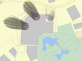
A lot has been going on in WikiMiniAtlas development recently. At Wikimania in DC I met Brian Jacobs, a user interface designer who made a ton of suggestion on how to improve the WMA user interface. The menu redesign is fully based on some of these suggestions. Also User:Dispenser has been enormously helpful with lots of suggestions and a rewrite of the backend database preprocessing (to make sure the data is even more up to date). When zooming in labels/thumbnails do not disappear but existing labels are displayed and more labels incrementally loaded. As a big improvement I have developed a client-side tile renderer, which increases the available zoomlevels substantailly (more than OpenStreetMap, GoogleMaps, or Bing Maps). Based on this infrasructure I was able to develop a 3D wireframe buildings display, which can currently be tested in the development version (see screenshots). --Dschwen (talk) 19:24, 31 July 2012 (UTC)
-
 Downtown Chicago with 3D buildings
 -
 Petronas Towers (complex 3D building geometry)
 -
 Experimenting with the start_date tag to enable time dependent maps
 -
 Improved commons thumbnail mode
 -
 Deep Zoom (scalebar is 5m, still not the maximum zoom level)


![[2]](https://commons.wikimedia.org/w/index.php?title=Image:Button_hide.png&diff=prev&oldid=12271051)
- The features mentioned abobe are live. And as of today Saturn's moon Titan is supported as well. --Dschwen (talk) 16:18, 9 August 2012 (UTC)
How to enlist new images with the map edit
I started to develop a page at commons:User:Nasir8891/Lists_of_Monuments_in_Bangladesh and i have used this map. But the problem is only a few images are enlisted on the map. How can i add more images based on the location?--Nasir Khan Saikat (talk) 11:51, 4 September 2012 (UTC)
- Make sure each image you want on the map has a {{Location}} template on it's image description page on commons. Data is extracted periodically and it may take some time for the images to show up on the map. --Dschwen (talk) 00:09, 10 September 2012 (UTC)
Media story about WikiMiniAtlas and other geodata features on Wikipedia edit
Some weeks ago we got contacted by a journalist asking questions about maps and geocoordinates on Wikipedia, and (with the help of Dispenser) pointed him to WikiMiniAtlas among other things. The resulting article has now come out on Talking Points Memo, and heavily features WikiMiniAtlas: http://idealab.talkingpointsmemo.com/2012/10/wikipedia-maps-inside-encyclopedias-little-known-cache-of-geo-data.php
Regards, Tbayer (WMF) (talk) 17:39, 12 October 2012 (UTC)
- This is great news. Looks like Dispenser did a really good job at pointing out the WMA features. --Dschwen (talk) 17:52, 26 October 2012 (UTC)
Can we make this work on Wikiversity? edit
Ni! Hi folks,
For over a year I've been working with some groups who study and work with sustainability issues here in Brazil, and geographical visualization is a big thing for them.
We've been producing case studies on Portuguese Wikiversity, documenting green roofs, urban farms, bike lanes, organic markets etc, and they got really excited when they first saw the WikiMiniAtlas within Wikipedia.
What we are producing is, for the most part, non-encyclopedic original research and sometimes project organization, so using Wikipedia is not an option — even if we do have an understanding that once they learn wiki they'll also want to contribute to Wikipedia with appropriate content. Our main goal is to develop their skills for collaboration with free knowledge, while producing knowledge that when shared will make their work on sustainability more effective.
So, is there any chance WikiMiniAtlas could be made to work in Wikiversity as well? And what about miniatlases that only show pages in specific categories?
If there is interest in working on this, we'd really like to assist, so do get in touch.
Cheers,
--Solstag (talk) 08:29, 30 October 2012 (UTC)
- Yes, I believe this should be possible. We can immediately start integrating WMA into the wikiversity configuration. The next step would be extracting the coordinate data from that wiki. I'll have to check how much work it will be to add support for different projects (wikiversity, wikipedia). Right now there is only the concept of "language" (and wikimedia commons as a special case). But we sould be able to add this. I've been meaning to add category support to WMA for quite a while now. I'll put it to the top of my list. --Dschwen (talk) 19:23, 30 October 2012 (UTC)
- Thanks, that's great to hear! My friends will be excited. I certainly am. Let us know in case we can help you out with testing and, if it would help, programming (there are two people in the group who can program, one of them has some mediawiki knowledge, the other is me, eheh). []s --Solstag (talk) 05:33, 1 November 2012 (UTC)
- Ok, we would need and admin to activate WMA on wikiversity so that I can start testing, and I would need you to point me to a few test pages (and categories) with coordinates. Do you know how to include WMA? --Dschwen (talk) 14:27, 1 November 2012 (UTC)
- I'm an admin at pt.wikiversity. The way I know to include would be to add a "mw.loader.load" line to "MediaWiki:Common.js". Is there a better way to do it? About the test pages, I guess I can copy the templates from pt.wikipedia and create a test page with coordinates on them, or just include the result of expanding the template as it may be simpler to test with that. I'll get to these as soon as you ok them! --Solstag (talk) 18:57, 1 November 2012 (UTC)
I suggest loading it like this. This avoids pulling the resource from meta if it is not needed. And i guess most of the pages on pt.wikiversity won't have coordinates on them. --Dschwen (talk) 19:11, 1 November 2012 (UTC)
// <nowiki>
( function ( $, mw ) {
    $( document ).ready( function() {
      var require_wikiminiatlas = !!$( 'div.kmldata' ).length;
      var coord_filter = /geohack/;
      $( 'a.external.text' ).each( function( key, link ) {
            if ( link.href && coord_filter.test( link.href ) ) {
                require_wikiminiatlas = true;
                // break from loop
                return false;
            }
        } );
        if ( require_wikiminiatlas ) {
            mw.loader.load( '//meta.wikimedia.org/w/index.php?title=MediaWiki:Wikiminiatlas.js&action=raw&ctype=text/javascript' );
        }
    } );
} )( jQuery, mediaWiki );
// </nowiki>
Cool. I added the above to [4] and included coordinates in [5] and [6]. Seems to be working, sort of ;). --Solstag (talk) 00:51, 2 November 2012 (UTC)
- I would say that works better than I expected. It uses labels from the portugese wikipedia. Ok, next steps are more labor intensive. Extracting coordinates and adding the category functionalty. --Dschwen (talk) 04:02, 2 November 2012 (UTC)
- Nice, let me know if there's anything else to help with. --Solstag (talk) 08:06, 2 November 2012 (UTC)
Hi there!
Just stopped by to ask what is the situation on this?
As far as I can tell right now I can include the map on a page, but it still does not show labels for other Portuguese wikiversity pages that also have coordinates. Or perhaps I am doing something wrong, since I included the map directly by URL, is some specific template name required?
I'm also asking because we are planning some work with a university course in the near future that may include mapping of Brazilian indigenous people, so it would be nice to know if we will have this working and, in any case, how we should go by to make sure whatever we do is functional once this ready.
Thanks again and cheers,
--Solstag (talk) 16:07, 29 March 2013 (UTC)
- That would require coordinate extraction from wikiversity pages. This is currently not set up as far as I know. I'll talk to User:Dispenser who extracts coordinates. --Dschwen (talk) 00:35, 12 April 2013 (UTC)
- That's very nice, please if possible also mention the possibility of map visualization by category, as that would be a very useful feature for this and future projects like it, not to mention also useful for Wikipedia. I don't know if you'd need some additional resources for getting this done, I'm willing to look for that if necessary. Thank you and cheers, --Solstag (talk) 17:23, 12 April 2013 (UTC)
KML styling edit
- At w:Oklahoma State Highway 82, the highway KML is rendered on WMA as blue lines, which makes it likely to be mistaken for a river. Could you use a more distinctive colour, such as red, that is unlikely to be mistaken for other features on the map?
- At w:AB postcode area, I have used the {{Attached KML}} template to provide the contiguous polygons for each of the districts in the area. They are correctly rendered by WMA, but the internal borders are almost invisible (faint pale lines), so it is practically impossible to see the boundaries between each polygon. Could you style polygons with darker borders and more transparent interiors, so that adjacent polygons have clearly visible borders?
Richardguk (talk) 18:15, 10 November 2012 (UTC)
- Hello Richard, these are sensible suggestions. I'll try adding borders to the polygons. I styles lines blue to for them to have a distinct appearance compared to the area data. Let me see if I can find another solution. --Dschwen (talk) 01:50, 11 November 2012 (UTC)
Greek (el) capital labels edit
......tend to repeat in most cases the name of the country. So instead of Tokyo (el:Τόκιο), one reads Japan, instead of Beijing one reads PRC and so on. Curiously, this is not the case for Canada (it is actually, Ottawa is marked as Canada), the UK or Spain where the labels London and Madrid are in the right place. France and Germany though are not that lucky...A not so in depth check on my part revealed that this is the case with most capitals. Thought I should report this, thanks.--Ptoliethron (talk) 05:57, 8 December 2012 (UTC)
Well, I guess the problem is on the countries infoboxes, as they include the capitals' coordinates without a name parameter. So the coordinates are assigned to the article's title. -Geraki TL 08:27, 8 December 2012 (UTC)
- Yeah, I'm aware of that and I have battled before with the infobox template guys on en. The best solution would be if countries were tagged with the geographical center and Capitals were tagged in their own articles. --Dschwen (talk) 00:01, 10 December 2012 (UTC)
CycleMap implementation edit
Hi there, it'd be really handy to have an implementation that showed bike routes, rather like OpenCycleMap, for instance for pgaes linked off List of cycleways. Would that be achievable, do you think?
- Hello Jim, that is a go idea. This is achievable for low zoom levels (which are rendered in the browser) by supplying custom style data for the map. I've meant to implement something like that fore a while now. Fo showing just single bike routes the WIWOSM data can be used (by tagging the bike route in OpenStreetMap). Then a bike route will show up automatically on the Map in the corresponding Wikipedia article. --Dschwen (talk) 02:58, 1 January 2013 (UTC)
Aspect ratio edit

The aspect ratio of the map seems out. Compare the map of Kirkstall Forge railway station with the open streatmap version [7] or google maps version [8] and it definitely looks squashed in the vertical direction.--Salix alba (talk) 08:46, 22 February 2013 (UTC)
- WMA uses a Plate Caree projection and not a Web Mercator projection. PC unlike WM can display the entire globe. WM cuts out the last few degres near the poles, but we have articles there that should be displayed. WM also has a much larger area distortion at low zoom levels (compare Greenland and Africa). This is a historic choice made 8 years ago when the WMA was still limited to low zoomlevels, while Google Maps was designed for use at very large zoomlevels (street level) where the dispropotionate areas you observe at global level do not matter. --Dschwen (talk) 17:22, 22 February 2013 (UTC)
- Maybe its time to review that decision. The WikiMiniAtlas is now frequently used for individual towns and geographical features at quite high zoom levels. Is there a way different projections could be used at different zoom levels? The distorsion also get more extreme near the polls Norway becomes short and fat rather than long and thin http://en.wikipedia.org/wiki/Norway --Salix alba (talk) 11:30, 24 February 2013 (UTC)
- Yeah, I've had that on my todo list for quite a long time now. There are a bunch of technical reasons why this is a difficult task though. --Dschwen (talk) 16:43, 24 February 2013 (UTC)
- Yes I appreciate that. Wondering if you could have a menu option to switch projection? I guess for high zoom the preferred projection would be orthogonal onto the tangent plane. It would only work locally though.--Salix alba (talk) 18:10, 24 February 2013 (UTC)
- A locally changing projection would be problematic due to the way the labels are stored internally. I need something tile based. Merkator for high zoom levels would be an option. I sore the labels for every map tile in a tree structure. I need a separate tree for every projection, as each one has completely different map tiles. --Dschwen (talk) 19:28, 24 February 2013 (UTC)
- Yes I appreciate that. Wondering if you could have a menu option to switch projection? I guess for high zoom the preferred projection would be orthogonal onto the tangent plane. It would only work locally though.--Salix alba (talk) 18:10, 24 February 2013 (UTC)
- Yeah, I've had that on my todo list for quite a long time now. There are a bunch of technical reasons why this is a difficult task though. --Dschwen (talk) 16:43, 24 February 2013 (UTC)
- I'm actively working on making this happening. This will allow me to use a better backend to render the tiles (eventually running on Wikimedia infrastructure). --Dschwen (talk) 21:30, 18 March 2013 (UTC)
E/W Longitude switches? edit
An anon IP editor raised a question about the MiniAtlas at en:talk:Bank of America. Looking at the atlas display for the two region articles mentioned, en:Liushi Shan and en:Guozha Lake, does confirm a Bank of America being shown in this area of Tibet/China. Though the en:Bank of America article does not appear to have any geo-coordinates included, a quick check indicates that the coordinates of either en:Bank of America Corporate Center (35.227778°N 80.843046°W) or en:Bank of America Plaza (Charlotte) (35.2266°N 80.8432°W) would, if changed to an East rather than West longitude, place them in that approximate area. In addition, that same general area (re-centering the map to nearby en:Kashgar) contains unexplained references to en:Round Top, Pennsylvania, en:Roxy Theatre (New York City), and en:Adas Israel Congregation (Washington, D.C.), all again closely approximating equivalent longitudes in the opposite direction). (en:August 1962 also shows up intermittently in the area, but I can't say how to reliably reproduce that result.) Any ideas? Fat&Happy (talk) 23:00, 16 June 2013 (UTC)
- Sorry, I missed this question. The coordinates on the WMA are extracted every once in a while and are not taken from the "live" wikipedia for technical reasons. So at one point in time (at the last extraction) these articles must have had wrong coordinates. These may now have been fixed, and will show up correctly after the next extraction run. --Dschwen (talk) 18:18, 18 July 2013 (UTC)
WikiMiniAtlas styling, and marker support edit
Hello,
I am creating KML maps for Wikipedia railway routes articles. I am using attached KML template.
There are two things missing
- The markers of stations are not displayed
- The colors of lines does not match colors in base KML file
Is there any solution to fix this?
Example: http://en.wikipedia.org/wiki/Vermonter
I would like to have similiar look and feel like on this propetriary map.
http://www.amtrak.com/vermonter-train
(click on map in top right corner)
--Jkan997 (talk) 15:12, 28 August 2013 (UTC)
- This would be possible, but I have two issues with this
- Point markers can already be realized by putting more coordinate templates into the article (as a List of stations), this keeps the data in easily editable wikitext
- Having a single line style keeps the maps consistent, which I consider a usability advantage
- However, having custom line styles would make sense if multiple different objects are shown on the map. --Dschwen (talk) 16:00, 28 August 2013 (UTC)
Translation edit
Would anyone object if I marked this for translation? PiRSquared17 (talk) 16:30, 26 September 2013 (UTC)
- No, sure, go ahead. How does this affect the existing translated subpages? --Dschwen (talk) 19:08, 27 September 2013 (UTC)
Filter by type, default to landmarks only edit
Please see the proposal at w:Wikipedia_talk:WikiProject_Geographical_coordinates#GPS.2C_MOS_and_events. --Piotrus (talk) 13:03, 13 January 2014 (UTC)
Update: WikiMiniAtlas is migrating to Wikimedia Labs edit
As the Toolserver is shutting down this summer I will be migrating the WMA over to labs. This is a complex endeavour, but I am making progress. The map label server is already running on labs, and the tile rendering servers are built. What is still missing is a database server with a copy of the OpenStreetMap database. This is promised by the WMF and as soon as they deliver I will finish the migration. --Dschwen (talk) 22:15, 12 February 2014 (UTC)
- A second migration step became necessary, as WMFLabs is moving to a new datacenter. The WikiMiniAtlas instance is now migrated to its (hopefully) final position. I'm copying some more map data over from the Toolserver and have debugged the label serving. So far it looks much more responsive than the version on the Toolserver. I'm still waiting for a copy of the OSM database to become available on labs. But the bulk of the migration work is done, and once OSM data becomes available the switch over from the Toolserver should be rather painless. --Dschwen (talk) 23:28, 13 March 2014 (UTC)
Update: Progress on high pixel density (retina) display optimization edit

on the labs version of WMA at http://wma.wmflabs.org/index_dev.html I'm working on retina display support. So far the high zoom levels adjust to the display pixel ratio of the device, which makes the map look nice on new MacBook Pros for example. The change was super easy, as the map at high zoom levels is rendered in the browser. --Dschwen (talk) 04:38, 15 March 2014 (UTC)
Update: tile rendering and satellite imagery working on labs edit
Over the weekend I got the on-demand tile rendering and satellite imagery fetching/rescaling working on labs. The OSM data is pulled through an ssh tunnel from across the atlantic ocean. The lag of this tunnel makes the rendering process painfully slow. But the point was setting everything up as complete as possible. As soon as the OSM db is set up on labs it will be a mere flick of a switch to have a fully operational WikiMiniAtlas. Also working ist the automatic article summary generation. --Dschwen (talk) 14:59, 17 March 2014 (UTC)
Update: switchover to labs edit
Today I have redirected all traffic to the WMA Labs instance. Performance seems to be ok so far. With the switchover come a few small improvements to the WMA. I have finally tweaked zoomlevel 11 which stuck out like a sore thumb with overly thick road lines. The old way of dwawing coast lines intruduced double-line costline artifacts continuing across land in N/S and E/W direction at high zoomlevels. These are gone now. Labels are now shortened to reduce clutter. Any appendixes to label strings following a comma , or in () brackets are hidden and only shown when hovering the label with the mouse. This mainly removes (US state) suffixes and such, which should be obvious from seeing the label on a map.
Unfortunately the onearth NASA server that was provinding 15m resolution landsat data was shut down. This is quite a big bummer. I did however copy all cached satellite data from the toolserver over to labs so in the interim (until a comparable service appears) there should be quite a bit of sat coverage in teh WMA. --Dschwen (talk) 22:36, 15 April 2014 (UTC)
Scowiki labels edit
How can I get scowiki labels enabled? Dschwen? --AmaryllisGardener talk 15:52, 29 November 2014 (UTC)
- Hey User:AmaryllisGardener, thanks for the translations (even though I don't even know what language that is ;-) ). I'll add them soon. --Dschwen (talk) 18:01, 30 November 2014 (UTC)
Not working edit
On all wikis that have WMA, (I haven't checked them all, but I assume this) WMA isn't working for me, the map is totally grey and at the bottom left it says "null". --AmaryllisGardener talk 03:23, 2 December 2014 (UTC)
- Same for me too; how should this be reported? TomHennell (talk) 19:10, 4 December 2014 (UTC)
- Now seems to be working again for me. TomHennell (talk) 00:38, 5 December 2014 (UTC)
- It seems it had to do with User:Dschwen adding translation info. Thank Dschwen, but I still don't see where you can select Scots on the list of languages where you can show article links on the map (If you're aware of this but haven't gotten around to it that's ok, I just wanted to make sure you knew.) Regards, :) --AmaryllisGardener talk 02:11, 5 December 2014 (UTC)
- Ahhh, sco = "Scots" :-). Anyhow, The WMA supports labels in 40 or 50 languages. The label language is determined by the project you are on. I agree that having the ability to switch languages on one hand, but having that list be incomplete is not optimal. Let me think a bit how I can improve that UI. Maybe I make it a full scrollable list, and add the 5 languages most often selected by the user to the top. --Dschwen (talk) 16:06, 5 December 2014 (UTC)
- Well, it's not the switching languages, but I can't see any article links on the map, like, if you look at sco:Stuttgart's WMA and zoom out, you'll see that WMA doesn't have any other links to articles on scowiki, and the "Shaw labels frae" is set to Arabic. --AmaryllisGardener talk 21:27, 5 December 2014 (UTC)
- Ahhh, sco = "Scots" :-). Anyhow, The WMA supports labels in 40 or 50 languages. The label language is determined by the project you are on. I agree that having the ability to switch languages on one hand, but having that list be incomplete is not optimal. Let me think a bit how I can improve that UI. Maybe I make it a full scrollable list, and add the 5 languages most often selected by the user to the top. --Dschwen (talk) 16:06, 5 December 2014 (UTC)
- Oh, sorry. I am dense today. I'll add sco to the list of supported languages and run the database extraction process. I will report back. --Dschwen (talk) 21:53, 5 December 2014 (UTC)
- Ok, done. I did not realize that we weren't doing label data extraction for scots yet. --Dschwen (talk) 22:03, 5 December 2014 (UTC)
- Thank you very much! :) --AmaryllisGardener talk 23:50, 5 December 2014 (UTC)
Update: Language selection UI polish, improved chinese support edit

The language selector for the map labels now lists all supported languages. The users' current Wikipedia UI language preference and the project language are listed at the top of the language list for easy access. I added automatic character conversion to enable displaying chinese labels in the regional charsets. This uses code from mediawiki. For users unfamiliar with that: We have one chinese wikipedia, on which users can select the chinese character variant they want the content displayed in. This selection is now respected by the WMA, which converts all labels to the selected variant on the fly. --Dschwen (talk) 20:42, 14 January 2015 (UTC)
Commons category picture map edit
Hi, I write here to ask if this might be possible to have with WMA, on Commons, for a picture category, a map representing locations of all pictures belonging to this category (with a geolocation specified)? If yes, how would that be feasible? Kelson (talk) 14:15, 27 February 2015 (UTC)
- I've been thinking about that for a while. Simple category would be trivial to implement. Deep category search would be a little harder (I have developed the FastCCI tool for that). --Dschwen (talk) 14:25, 27 February 2015 (UTC)
- Thank you for your quick answer. Our use case does not need a sub-category visitor. The Swiss National library upload collections, for example this one with Eduard Spelterini's travel pictures or This one with old landscape picture from all around Switzlerland. The idea is to propose a WMA map/widget proposing an other way to navigate through the collection. This map would be inserted in the Category page of course, but also wherever it makes sense to show these pictures. Does it make sense to open a feature request on github for this? Kelson (talk) 16:06, 27 February 2015 (UTC)
- Yeah, go ahead and lets track this on github. I'll work on this feature next. --Dschwen (talk) 01:23, 28 February 2015 (UTC)
- Hi. I have created a feature request with a mockup here. Please let me know if something is still unclear about it. Regards Kelson (talk) 12:15, 28 February 2015 (UTC)
502 Bad Gateway error edit
WikiMiniAtlas is failing with a "502 Bad Gateway nginx/1.5.0" error message. Happening with Chrome v.43, Firefox v.38, IE11 on Windows 7, both logged in and logged out, across multiple articles and multiple language versions of Wikipedia. - Evad37 (talk) 05:53, 24 June 2015 (UTC)
- I'm getting the error too. :( --AmaryllisGardener talk 18:19, 7 July 2015 (UTC)
- It looks like work is ongoing at phab:T103358. --Quiddity (talk) 18:28, 7 July 2015 (UTC)
Sorry, I didn't see these comments. I did open a separate ticket a few days ago. I hope the data gets restored soon. --Dschwen (talk) 02:15, 10 July 2015 (UTC)
- Despite phab:T103358 being closed as "Done", and maps on Wikivoyage apparently working, maps on Wikipedia are not: Paris. -- Michael Bednarek (talk) 13:55, 14 July 2015 (UTC)
- It seems I was too impatient; it's now working. -- Michael Bednarek (talk) 10:24, 16 July 2015 (UTC)
- Despite phab:T103358 being closed as "Done", and maps on Wikivoyage apparently working, maps on Wikipedia are not: Paris. -- Michael Bednarek (talk) 13:55, 14 July 2015 (UTC)
synchronization with openstreetmap database edit
How often does the WikiMiniAtlas update it's information from the OpenStreetMap source data? Is this a regular scheduled process? Also from which database are the text label links on the WMA actually taken? I thought they were from OSM, but comparing a WMA map from a geolinked wikpedia article and the OSM page directly, they look different.
- in answer to my own question after getting the details from User:Dispenser.
The text labels for WMA are maintained in a database populated from external links to GeoHack. The article title or &name= parameter is used as the display text (with language specific adjustments). The process was run daily on Toolserver (now decommissioned), but last update was in Jan 2015. User:Dispenser will be addressing the issue.
WikiMiniAtlas and WIWOSM edit
I have only recently noticed that the WikiMiniAtlas on English Wikipedia sometimes shows line and area features. This is very informative for rivers and highways. Some of these come from an intricate process involving templates and KML code. Others come from a process called WIWOSM using spatial data already captured for the Open Street Map project.
I am looking for two things at the moment that I haven't found:
- A useful tutorial to help Wikipedia editors and OSM editors to make sure their work is visible to the widest audiences in the most helpful ways. e.g. whether a coordinate template is needed to trigger the OSM, even when a single point is either useless or misleading for some linear features? Is there a convention for which point to choose?
- A meaningful status page that shows which bits work, which bits don't at the moment, and how to report, help fix or answer "when?" for bits that are broken.
This talk page currently looks like the best place to ask, but the conversations above suggest it may still not be the right one. Any suggestions? Thanks. --ScottDavis (talk) 03:44, 8 November 2015 (UTC)
Data priority enquiry edit
The explanation says
Textual labels on the map are generated from a database by en:User:Dispenser. Labels are sorted according to importance into a quadtree data structure for fast retrieval.
I wonder if there is an explanation somewhere on what are the inputs to "importance"? Are they different for each wiki, or done once for all languages? I find the WikiMiniAtlas to be a wonderful tool to work out where things are, but often notice as I zoom in or out that some quite obscure place/thing shows up on the map in a space where it looks like space for a more significant town or item would make more sense to assist readers to orient themselves. Most of them are fine, so I wonder if it is driven by Wikiproject Importance ratings, or article length, or most recent edit? Thank you. --ScottDavis (talk) 21:55, 9 January 2016 (UTC)
- @Dispenser: - I failed to ping anyone in the initial question. Sorry. --ScottDavis (talk) 08:55, 10 January 2016 (UTC)
- @ScottDavis: The person to ping would be me :-). You can google for a talk I gave on WikiMiniAtlas at Wikimania a while ago. I am hesitant to disclose the importance metric, as "importance" is a rather subjective thing and I'm worried about endless discussions on it ;-). Your point is taken though, but the issue is oftentimes that the geodata on Wikipedia is faulty. Cities are not properly tagged with a `city(population)` type in the coordinates template. If they are, the population number is used in the ranking, so that big cities should get prioritized heavily. I'm looking into utilizing wikidata for the importance ranking, as the data there seems more reliable. --Dschwen (talk) 16:20, 10 January 2016 (UTC)
- @Dschwen: Thanks and sorry Daniel. I don't think I have found the page you mean though. I found [9] but the link to the 2012 slides seems to be dead and I failed to find 2015 proceedings.
- I understand your point about arguing about the importance metric. At the moment, I wasn't thinking of that, I was looking to understand the one in current use, which I guess means I am trying to "game the system", even though my motive is to advance to project. For example, at the 20km and 10km scales, the atlas on en:Mallala, South Australia displays a dot for en:Whitwarta, South Australia rather than the more well-known en:Balaklava, South Australia to the north. I'm prepared to work to improve the microformat data generated by infoboxes or to source and add relevant information if I knew what things are used. It's also hard to tell whether changes I make or find in Wikipedia (or OpenStreetMap for vector data) didn't make a difference, or just haven't made a difference yet.
- Looking critically at the map in that area, I guess the "importance metric argument" arises with whether en:Mallala, South Australia (a rural service town) is more or less "important" than en:Mallala Motorsport Park (a racetrack near the town that holds a round of several national series). At the moment, the race track appears on the MiniAtlas at wider zoom levels than the town. I can see arguments both ways for that particular argument. --ScottDavis (talk) 10:30, 11 January 2016 (UTC)
- @ScottDavis: Sorry for the late reply, but if you can understand perl a bit you can look at https://github.com/dschwen/wikiminiatlas_servers/blob/master/maintenance/build_qtree_index.pl starting at line 202 the $weight variable is computed. You can see that the coordinate type information and city population numbers for city(10000) for exampel enter the weight. But so does the article length. --Dschwen (talk) 20:59, 30 January 2016 (UTC)
- @Dschwen: Thank you. That shows what I wanted to see. I don't know Perl well, so will study it sometime and work out what needs to be improved in the articles that don't show up when I think they should. Possibly we just need to add content so the articles for "more important" places are longer than the articles for interesting but small places.
- Something I noticed in passing was that the constant
$auterritoriesis missing|Tasmania|Australian Capital Territoryso places in that state and territory get much bigger labels. --ScottDavis (talk) 09:29, 1 February 2016 (UTC)
- @ScottDavis: Sorry for the late reply, but if you can understand perl a bit you can look at https://github.com/dschwen/wikiminiatlas_servers/blob/master/maintenance/build_qtree_index.pl starting at line 202 the $weight variable is computed. You can see that the coordinate type information and city population numbers for city(10000) for exampel enter the weight. But so does the article length. --Dschwen (talk) 20:59, 30 January 2016 (UTC)
New FAQ or request for a dashboard edit
The WikiMiniAtlas is great, but depends on a range of caches and databases in the background. The FAQ would be along the lines of "When will my recent edit show up in WMA?"
The page currently has seven bullet points under Data Sources. At the very least, the text labels depend on a database of locations extracted from Wikipedia. Maybe one big database, maybe one for each language. The WIWOSM shapes extracted from OpenStreetMap also relies on a data dump/cache. It would be helpful to have a single place to go to that displays when was each component cache last refreshed and when it is scheduled to be updated next. This would help editors to know when to go back and check their edits display as expected, and help maintainers to notice if there is a problem in the process somewhere.
My current trigger for this is that I used WikiMiniAtlas to discover several articles that had coordinates in enwiki that were a long way from where they should be. I have fixed a number of these, but it does not look like edits on enwiki have made it through whatever data dumps and caches to get to update the points in WikiMiniAtlas since about the second week of December. --ScottDavis (talk) 00:37, 17 February 2016 (UTC)
- @ScottDavis: What a coincidence, I used it for the very same reason today! And yes, I too would like to know when my edits will show up. --AmaryllisGardener talk 03:14, 19 February 2016 (UTC)
Update edit
I was wondering, when will article coordinate data be updated for scowiki next, or how often does it? --AmaryllisGardener talk 18:44, 22 August 2016 (UTC)

@AmaryllisGardener: I guess it's a little late... but I have picked work back up on the WMA and am using scowiki as my test wiki (as it is managably small). Labels are coming back, and in fact they shoudl be working for scowiki already. --Dschwen (talk) 19:19, 19 January 2021 (UTC)
KML from other wikis edit
@Dschwen: Correct me if I'm wrong, but it seems like the following code in w:en:Template:Attached KML is what enables KML files to be shown in WMA:
<div class="kmldata" title="Template:Attached_KML/{{#if:{{{from|}}}|{{{from|}}}|{{PAGENAME}}}}" style="display:none;">[[Template:Attached_KML/{{#if:{{{from|}}}|{{{from|}}}|{{PAGENAME}}}}]]</div>
Is there something similar a template/module can use if the KML is from another wiki? e.g. the fifth test at w:en:Template:Attached KML/testcases uses this kml file from fr Wikipedia. Assuming d:Wikidata:Property proposal/KML file gets approved, there could be many instances of KML files coming from another wiki; it would be good if they were supported in WMA - Evad37 (talk) 09:56, 22 August 2016 (UTC)
- @Evad37: the code you quoted just helps the WMA discover that the Attached KML template is inserted in the page. The actual data is stored in a subbage of said template. Fetching this page from another wiki (or straight up from wikidata) may need some proxying but can be done. --Dschwen (talk) 23:01, 22 August 2016 (UTC)
- @Dschwen: So if I make the new version of the template/module I'm writing output something like this:
<div class="kmldata" data-server="server" title="kmltitle" style="display:none;">[[interwikiprefix:kmltitle]]</div>
- with actual values such as
fr.wikipedia.orgforserver,w:fr:forinterwikiprefix, andModèle:KML joint/Ligne Lausanne – Bercherforkmltitle. Would that work for you, or would you prefer some other format? - Evad37 (talk) 02:39, 23 August 2016 (UTC)
- @Dschwen: So if I make the new version of the template/module I'm writing output something like this:
- Yeah, that would work, but it would require some development on my part. If you point me to a demo page where the new template is used (once it exists) I can get started on this. --Dschwen (talk) 18:14, 23 August 2016 (UTC)
- @Dschwen: Created on Simple English Wikipedia, see w:simple:Category:Articles using KML from Wikidata. Also used on w:en:Template:Attached KML/testcases2. - Evad37 (talk) 10:01, 26 August 2016 (UTC)
- @Dschwen: any updates? The module is now active on enwiki, as well as jawiki (e.g. w:ja:ハドソン・ストリート_(マンハッタン)) - Evad37 (talk) 09:36, 3 September 2016 (UTC)
- Sorry, I have been busy IRL. I'll take a look at this. --Dschwen (talk) 15:38, 18 September 2016 (UTC)
- @Dschwen: any updates? The module is now active on enwiki, as well as jawiki (e.g. w:ja:ハドソン・ストリート_(マンハッタン)) - Evad37 (talk) 09:36, 3 September 2016 (UTC)
- @Dschwen: Created on Simple English Wikipedia, see w:simple:Category:Articles using KML from Wikidata. Also used on w:en:Template:Attached KML/testcases2. - Evad37 (talk) 10:01, 26 August 2016 (UTC)
- Yeah, that would work, but it would require some development on my part. If you point me to a demo page where the new template is used (once it exists) I can get started on this. --Dschwen (talk) 18:14, 23 August 2016 (UTC)
Coordinates of other articles from Wikipedia edit
@Dschwen and Dispenser: Is there any information on what is broken that coordinates do not seem to be getting from new and changed enwiki articles into the WikiMiniAtlas? I'd be happy to try to help fix it, but don't know where to start looking for "it". It could be that I have fixed coordinate values in one wiki, but the data is drawn from another language or wikidata which might still be wrong. It could be that the database is no longer automatically updated, or that the link from the database to the MiniAtlas has died in some way. It is frustrating to see labeled points in the wrong place on the map, so trying to fix them shows they were fixed by someone else a long time ago but still show in the old place. Thank you for creating the useful tools, and sorry if we seem ungrateful that they are not "perfect". --ScottDavis (talk) 01:20, 9 February 2017 (UTC)
- Hello Scott, I'll look into it. --Dschwen (talk) 01:52, 6 March 2017 (UTC)
- @Dschwen and Dispenser: Is there work in progress about coordinates of nearby articles into the miniatlas? That entire layer seems to be missing completely for me lately :-( I fear I complained too much about it being out of date, so it got turned off - or is there a new preference I haven't found and need to turn on? --ScottDavis (talk) 00:08, 27 December 2017 (UTC)
- @ScottDavis: There's an ongoing discussion about the why the nearby articles layer is missing on the Wikimedia Forum (permalink). Needless to say, it's not because of your comments here. PiRSquared17 (talk) 03:12, 10 August 2018 (UTC)
- Thank you. --ScottDavis (talk) 06:09, 10 August 2018 (UTC)
- @ScottDavis: There's an ongoing discussion about the why the nearby articles layer is missing on the Wikimedia Forum (permalink). Needless to say, it's not because of your comments here. PiRSquared17 (talk) 03:12, 10 August 2018 (UTC)
- @Dschwen and Dispenser: Is there work in progress about coordinates of nearby articles into the miniatlas? That entire layer seems to be missing completely for me lately :-( I fear I complained too much about it being out of date, so it got turned off - or is there a new preference I haven't found and need to turn on? --ScottDavis (talk) 00:08, 27 December 2017 (UTC)
- @ScottDavis: The database layout on the WMF cloud was drastically changed breaking the way we were extracting and processing coordinates. I was disappointed by that and demotivated. Anyhow. I'm back now with fresh ideas to get everything working again even with the restricted database functionality. --Dschwen (talk) 17:25, 16 January 2021 (UTC)
- @Dschwen: Thank you! I understand about things happening that lead to periods of demotivation. I'm glad you are back and look forward to seeing this layer return if it is technically possible. If there is anything I might be able to help with, I'd be happy to try to contribute. --ScottDavis (talk) 12:43, 20 January 2021 (UTC)
- @ScottDavis: The database layout on the WMF cloud was drastically changed breaking the way we were extracting and processing coordinates. I was disappointed by that and demotivated. Anyhow. I'm back now with fresh ideas to get everything working again even with the restricted database functionality. --Dschwen (talk) 17:25, 16 January 2021 (UTC)
- @ScottDavis: thanks for the offer! It would be really great to have another person on the project. There is JavaScript, PHP, and python development to be done... and some C++ for the tile rendering (which I need to look at soon). Also SQL for optimizing DB queries is always helpful (MySQL/MariaDB for the labels and PostgreSQL for the geo spatial data). Let me know if there are any aspects that interest you. --Dschwen (talk) 23:12, 21 January 2021 (UTC)
- @Dschwen: All things I have dabbled with at times, but none I claim significant expertise in :-/ I guess I should have a proper look at the github sometime soon. --ScottDavis (talk) 04:17, 22 January 2021 (UTC)
- @ScottDavis: thanks for the offer! It would be really great to have another person on the project. There is JavaScript, PHP, and python development to be done... and some C++ for the tile rendering (which I need to look at soon). Also SQL for optimizing DB queries is always helpful (MySQL/MariaDB for the labels and PostgreSQL for the geo spatial data). Let me know if there are any aspects that interest you. --Dschwen (talk) 23:12, 21 January 2021 (UTC)
How to get Attached KML to show up edit
I added a KML with the Attached KML template to https://en.wikipedia.org/wiki/Thong_Lo However I don't see an overlay in the WikiMiniAtlas dropdown. Am I doing anything wrong? Matthewmayer (talk) 12:37, 1 May 2017 (UTC)
- Uhm, sorry, missed this comment. It does show up for me, so I guess this is resolved? --Dschwen (talk) 14:29, 30 August 2017 (UTC)
Problem edit
Hellow! The problem in displaying borders Ukraine-Russia. This map [10] Crimea displaying as a Russian, but this is disputed territory Ukraine-Russia. --くろねこ Обг. 19:47, 11 May 2018 (UTC)
Not working on the Czech Wikipedia edit
@Dschwen: Hello, on cswiki WikiMiniAtlas gadget does not work anymore, could you help? We suspect this is due to changes in our Coord template. What should Coord template fulfill to make WikiMiniAltas work there again? Or do we have got some error in our gadget definition? (w:cs:MediaWiki:Gadgets-definition and w:cs:MediaWiki:Gadget-WikiMiniAtlas.js) --Dvorapa (talk) 16:53, 10 September 2019 (UTC)
- Currently being solved on technical Village pump. --Dvorapa (talk) 17:02, 1 October 2019 (UTC)
Unable to get shape overlays of places with an area to work edit
![]() You are invited to join the discussion at w:Template_talk:Coord#Shape_overlays_of_places_with_an_area?. I've asked at the Technical Village Pump on en-WP and no one there seems to know. {{u|Sdkb}} talk 18:45, 17 November 2020 (UTC)
You are invited to join the discussion at w:Template_talk:Coord#Shape_overlays_of_places_with_an_area?. I've asked at the Technical Village Pump on en-WP and no one there seems to know. {{u|Sdkb}} talk 18:45, 17 November 2020 (UTC)
I'm working on this again edit
I have resumed work on WMA. My first priority is to get the database adapted to the new cloud restrictions (no user DBs on replicas, no cross db joins). This will mean that labels are coming back. I will slowly try to address the backlog of bug reports on this page and address these issues. Sorry for the hiatus! --Dschwen (talk) 17:22, 16 January 2021 (UTC)
- Success. Over the next few days I'll be running the new extraction scripts on all wikipedias. sco and es are already working. enwiki script is currently running. --Dschwen (talk) 19:35, 19 January 2021 (UTC)
- ar ca cs da el en eo es eu fa pt sco tl vi vo Wikipedias are woking again. Italian is processing right now. Globes (moon etc are working as well, see en:Kepler_(lunar_crater). --Dschwen (talk) 05:20, 20 January 2021 (UTC)
- Thanks for your efforts. Particularly looking forward to the latest map overlays through an WIWOSM update. --The Equalizer (talk) 02:10, 25 January 2021 (UTC)
Argh, I just tweaked the database schema and accidentally dropped a crucial table erasing all labels on all wikipedias :-(. Running the extraction again. http://wma.wmflabs.org/status.php --Dschwen (talk) 02:56, 26 January 2021 (UTC)
- Thank you for the effort it looks great, and I've already fixed the coordinates on one article that was way out of place. --ScottDavis (talk) 05:16, 27 January 2021 (UTC)
- @Dschwen: Thanks for your work on this! I'm unfortunately still not seeing the map overlay I'm looking to have at w:Pomona College. Would you know, am I doing something wrong with how I entered it on Wikidata, or is there just still backend work that needs to process? It's been connected to Wikidata for months now, so I was expecting it to show up once the backlog was cleared. :/ {{u|Sdkb}} talk 04:03, 24 August 2021 (UTC)
Commons Map Update edit

At low zooms I'm now filtering out all images with a score less than the median score of the zoom level. This removes low score images (mostly with wrong coordinates) that would pop in the oceans. Over all this better reflects the spatial density of geocoded images in Commons. I'll add an option to disable this median filtering in the near future. --Dschwen (talk) 16:51, 31 January 2021 (UTC)
Show bounding box on map edit
Is there a way to craft a link to spawn a WikiMiniAtlas view that initially shows only a rectangular area bounded by specific lines of latitude and longitude? I would like to use such a feature to visualize individual Canadian National Topographic System map sheets. I have developed an algorithm to calculate bounding box coordinates of an NTS map sheet, using just its number-letter-number identifier (e.g., 092G06 for the map sheet that includes Downtown Vancouver) as an input. -- Denelson83 (talk) 20:52, 13 August 2021 (UTC)
Adding WikiMiniAtlas to Infobox edit
Hello! I am having difficulty with adding WikiMiniAtlas to an infobox on the page for en:Bailey_Yard. Could anyone please assist me in this endeavour? When clicking the globe icon at the top right near coordinates, the proper area overlay for the corresponding WikiMiniAtlas appears. However, within the infobox, only a generic map is shown. Thank you! Top5a (talk) 12:19, 3 May 2022 (UTC)
Bug report: "type" not working correctly for cities edit
For every article with Template:Infobox settlement, WikiMiniAtlas displays the marker on the map as a city marker, sized appropriately according to population. However, for every article for which "type" (in template:coord) is set to "city", the marker on the map displays it as if the type were "landmark", even if it also has the infobox. Examples: w:en:Sacramento and w:en:San Jose, California. --Numberguy6 (talk) 01:46, 20 October 2022 (UTC)
Update frequency edit
Hi, is the extraction run periodically? Based on https://wma.wmcloud.org/logs/ it looks like the last extraction was on 2023-02-09. The RedBurn (talk) 18:41, 1 October 2023 (UTC)
How to contribute to Moon, Mars, Venus, Mercury, Io and Titan maps ? edit
OpenStreetMap is clear for Earth Geodata, but how does the contribution work for the planets and moons ? Would also be interesting for https://en.wikipedia.org/wiki/Marble_(software) Dulliman (talk) 14:53, 5 November 2023 (UTC)
No search box edit
How do I search for my home town? Jidanni (talk) 04:50, 23 March 2024 (UTC)